ZCZC SPCFWDDY1 ALL
FNUS21 KWNS 261641
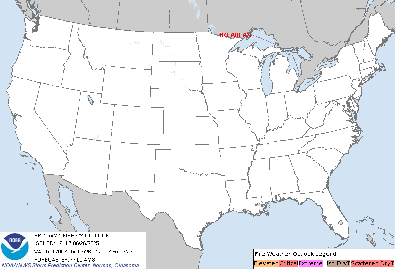
Day 1 Fire Weather Outlook
NWS Storm Prediction Center Norman OK
1141 AM CDT Thu Jun 26 2025
Valid 261700Z - 271200Z
...NO CRITICAL AREAS...
A subtle mid-level short wave trough will exit the Great Basin into
the Northern Rockies this afternoon. Mid-level flow and surface
pressure gradients will relax across the Great Basin as the trough
ejects northeastward through the day although resulting in sustained
west-southwest surface winds around 10-15 mph during peak boundary
layer mixing. However, locally elevated fire weather conditions,
particularly leeward of mountain ranges within the Great Basin and
northwestern Arizona and southwest Utah, can be expected today.
Stronger winds of 15-25 mph are likely across the upper Snake River
Plain but fuels are not as receptive to wildfire spread as regions
farther south.
..Williams.. 06/26/2025
.PREV DISCUSSION... /ISSUED 1248 AM CDT Thu Jun 26 2025/
...Synopsis...
Fire weather concerns are expected to remain limited for today
across the country. Widespread rainfall over the eastern two-thirds
of the country will limit fuel status for most locations. West of
the Rockies, dry conditions will continue with afternoon RH minimums
in the teens expected. However, the strongest low/mid-level flow is
expected to remain across the Pacific Northwest (where RH reductions
won't be as pronounced) ahead of a low-amplitude mid-level trough.
Localized elevated conditions may materialize across portions of
southern ID and northern NV where the overlap of dry conditions,
receptive fuels, and modest surface winds (15-20 mph) is most
probable. Latest high-res ensemble guidance generally shows a weak
signal for widespread and/or persistent elevated conditions, which
limits confidence in the overall fire weather threat.
...Please see www.spc.noaa.gov/fire for graphic product...
CLICK FOR DAY 1 FIREWX AREAL OUTLINE PRODUCT (KWNSPFWFD1)


 @NWSSPC
