|
| Mesoscale Discussion 341 |
|
[an error occurred while processing this directive]
|
|
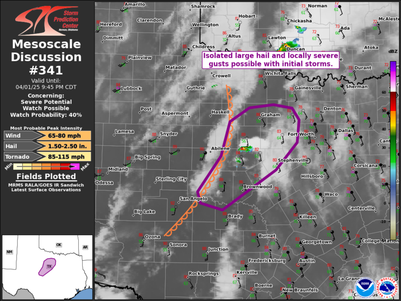
   Mesoscale Discussion 0341
   NWS Storm Prediction Center Norman OK
   0745 PM CDT Tue Apr 01 2025

   Areas affected...Portions of central and northwest Texas

   Concerning...Severe potential...Watch possible

   Valid 020045Z - 020245Z

   Probability of Watch Issuance...40 percent

   SUMMARY...Isolated large hail and locally severe gusts are possible
   with initial discrete storms in central/northwest Texas. It is
   unclear if severe coverage will warrant a watch, though trends are
   being monitored.

   DISCUSSION...An isolated thunderstorm has developed ahead of the
   dryline in central/northwest Texas -- where steep boundary-lapse
   rates are intersecting the western edge of the warm/moist sector
   (upper 50s/lower 60s F dewpoints). Weak large-scale forcing for
   ascent and 40-50 kt of cross-boundary 0-6 km shear (per DYX VWP)
   will support discrete supercellular structures, aided by around 2000
   J/kg MLCAPE. Initial storms will mainly pose a risk of isolated
   large hail and locally severe gusts. However, if these storms can
   persist long enough and track eastward into the increasing low-level
   shear/SRH, the tornado threat would also increase. The overall
   coverage and evolution of storms remains unclear, though trends are
   being monitored for a possible watch.

   ..Weinman/Mosier.. 04/02/2025

   ...Please see www.spc.noaa.gov for graphic product...

   ATTN...WFO...FWD...SJT...

   LAT...LON   32369948 33039928 33319883 33379826 33309783 33079767
               32639772 32099822 31319944 31449993 31660001 32369948

   MOST PROBABLE PEAK TORNADO INTENSITY...85-115 MPH
   MOST PROBABLE PEAK WIND GUST...65-80 MPH
   MOST PROBABLE PEAK HAIL SIZE...1.50-2.50 IN
|
|
Top/All Mesoscale Discussions/Forecast Products/Home
|
|


 @NWSSPC