|
| Mesoscale Discussion 362 |
|
[an error occurred while processing this directive]
|
|
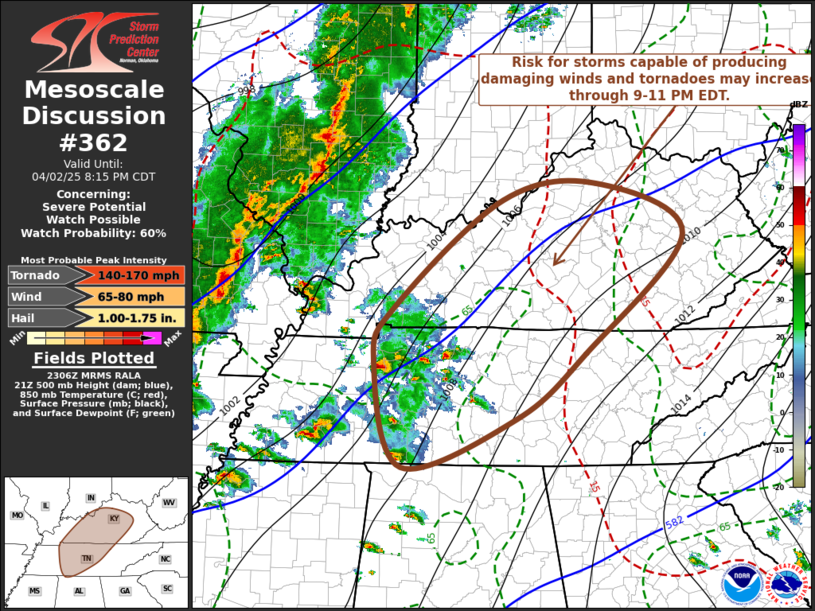
   Mesoscale Discussion 0362
   NWS Storm Prediction Center Norman OK
   0609 PM CDT Wed Apr 02 2025

   Areas affected...parts of middle Tennessee through central Kentucky

   Concerning...Severe potential...Watch possible

   Valid 022309Z - 030115Z

   Probability of Watch Issuance...60 percent

   SUMMARY...The risk for strong to severe convection, including
   supercells, posing a risk for damaging wind gusts and tornadoes may
   increase through 9-11 PM EDT.  Trends are being monitored for the
   possibility of a watch.

   DISCUSSION...A clustering of discrete thunderstorm development,
   likely supported by forcing associated with broad low-level warm
   advection, and perhaps a weak perturbation within the strong
   southwesterly flow aloft, probably will continue developing
   northeastward within a slowly moistening boundary layer across the
   Mid South into lower Ohio Valley.  This activity still appears
   embedded within a broadly anticyclonic low-level regime across
   northwestern Mississippi through western and middle Tennessee, but
   the Rapid Refresh suggests that surface pressure falls may lead to
   weak troughing across south central through east central Kentucky by
   01-02Z.  It appears that this will coincide with substantive further
   strengthening of low-level flow (50-70+ kt around 850 mb).  If
   inhibition does not become suppressive to convection, with the onset
   of diurnal cooling, the risk for tornadoes and damaging wind gusts
   may increase through mid to late evening.

   ..Kerr/Hart.. 04/02/2025

   ...Please see www.spc.noaa.gov for graphic product...

   ATTN...WFO...MRX...JKL...ILN...LMK...OHX...HUN...PAH...MEG...

   LAT...LON   36878779 38178619 38378477 37758348 36328495 35538598
               34958768 36238809 36878779

   MOST PROBABLE PEAK TORNADO INTENSITY...140-170 MPH
   MOST PROBABLE PEAK WIND GUST...65-80 MPH
   MOST PROBABLE PEAK HAIL SIZE...1.00-1.75 IN
|
|
Top/All Mesoscale Discussions/Forecast Products/Home
|
|


 @NWSSPC