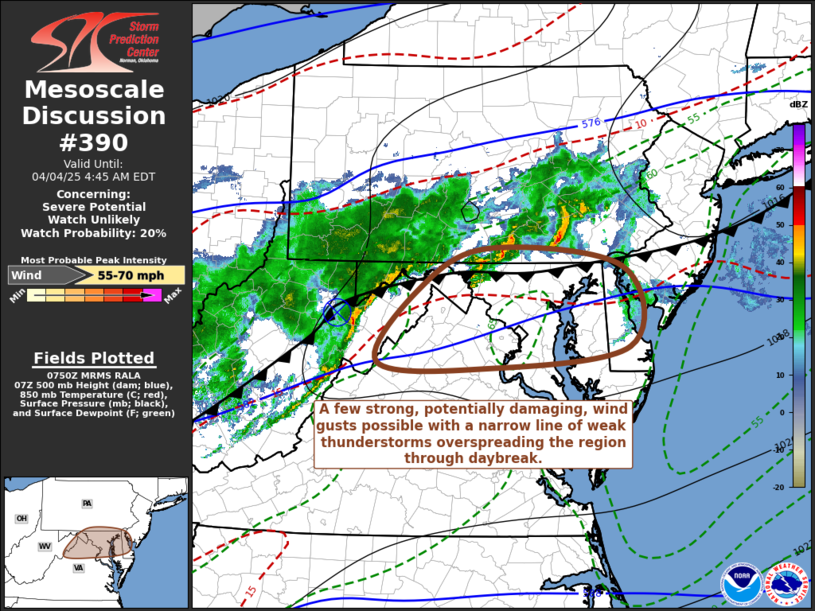
   Mesoscale Discussion 0390
   NWS Storm Prediction Center Norman OK
   0252 AM CDT Fri Apr 04 2025

   Areas affected...ern WV Pnhdl...nrn VA...MD...DC...srn PA...DE...srn
   NJ

   Concerning...Severe potential...Watch unlikely

   Valid 040752Z - 040845Z

   Probability of Watch Issuance...20 percent

   SUMMARY...Strong, potentially damaging wind gusts, may accompany
   weak thunderstorm activity likely to spread east of the Blue Ridge
   and across the Greater Washington D.C./Baltimore metropolitan areas
   through 6-7 AM EDT.  It is not clear that a severe weather watch is
   needed, but trends are being monitored.

   DISCUSSION...A narrow line of thunderstorms has shown some
   intensification, near and south of a wave or weak MCV now east of
   Elkins WV.  This activity has been propagating rapidly eastward,
   along and just south of a slow moving or stalling cold front,
   around 50 kt, which is about the strength of the mean westerly
   deep-layer ambient mean flow across the Allegheny Mountains into
   northern Mid Atlantic.

   Due to generally weak deep-layer lapse rates, CAPE along this
   corridor is quite weak west of the mountains, but improves somewhat
   (CAPE to 500 J/kg) in better low-level moisture across northern
   Virginia through southern New Jersey.  While some further
   intensification to the east of the Blue Ridge is possible as
   activity rapidly advances eastward through 11-12Z, thunderstorm
   intensities are likely to remain rather modest, based on forecast
   soundings.  However, unsaturated profiles in lower/mid-levels, may
   contribute to evaporative cooling and downward momentum transport of
   rear-inflow, which may undergo some further convective augmentation.

   ..Kerr/Mosier.. 04/04/2025

   ...Please see www.spc.noaa.gov for graphic product...

   ATTN...WFO...PHI...AKQ...CTP...LWX...

   LAT...LON   39897751 39677548 38737539 38497760 38557915 39397855
               39897751

   MOST PROBABLE PEAK WIND GUST...55-70 MPH
|


 @NWSSPC