|
| Mesoscale Discussion 394 |
|
[an error occurred while processing this directive]
|
|
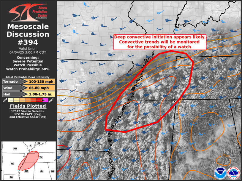
   Mesoscale Discussion 0394
   NWS Storm Prediction Center Norman OK
   1257 PM CDT Fri Apr 04 2025

   Areas affected...portions of northern Mississippi...western
   Tennessee/Kentucky...and eastern Arkansas

   Concerning...Severe potential...Watch possible

   Valid 041757Z - 042000Z

   Probability of Watch Issuance...60 percent

   SUMMARY...Deep convective initiation appears likely in the next
   couple of hours.  Storms that are able to develop robust updrafts
   will pose a severe weather threat through the afternoon. Depending
   on convective trends, a tornado watch may be needed this afternoon.

   DISCUSSION...Convective initiation appears likely within a deepening
   cumulus field across the open warm sector.  Continued heating and
   destabilization (MLCAPE already over 2000 J/kg into Tennessee per
   mesoanalysis) across the area with negligible convective inhibition
   should result in convective initiation, despite the lack of a
   specific focus.  While the integrated instability profile appears
   favorable for deep convection, a warm layer above 700 mb is
   contributing to weaker midlevel lapse rates.  In fact, the latest
   CAM runs indicate convective initiation across the region, but they
   struggle to produce simulated storms with robust updrafts.
   Nevertheless, for any storms that are able to develop strong
   updrafts, the kinematic environment will support supercells with
   tornado potential, given sufficient low-level and deep-layer shear.
   The convective trends will continue to be monitored for the
   possibility of a tornado watch.

   ..Jirak/Thompson.. 04/04/2025

   ...Please see www.spc.noaa.gov for graphic product...

   ATTN...WFO...OHX...HUN...PAH...MEG...JAN...LZK...

   LAT...LON   33839135 34329131 35199068 35809005 36488932 36788887
               36898827 36778759 36448725 35578747 35038791 34548846
               34158896 33769045 33839135

   MOST PROBABLE PEAK TORNADO INTENSITY...100-130 MPH
   MOST PROBABLE PEAK WIND GUST...65-80 MPH
   MOST PROBABLE PEAK HAIL SIZE...1.00-1.75 IN
|
|
Top/All Mesoscale Discussions/Forecast Products/Home
|
|


 @NWSSPC