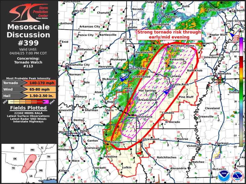
   Mesoscale Discussion 0399
   NWS Storm Prediction Center Norman OK
   0533 PM CDT Fri Apr 04 2025

   Areas affected...Northeast TX/Northwest LA into central/northern AR

   Concerning...Tornado Watch 113...

   Valid 042233Z - 050000Z

   The severe weather threat for Tornado Watch 113 continues.

   SUMMARY...Tornado potential, including a strong (EF2+) tornado risk,
   will be maximized through early evening across the ArkLaTex,
   especially across far northeast Texas into southwest Arkansas, while
   also increasing across north-central Arkansas. Tornado Watch 113
   continues until 9pm CDT/02z.

   DISCUSSION...Multiple intense supercells are ongoing at 525pm
   CDT/2225z across far northeast Texas and extreme southeast
   Oklahoma/far southwest Arkansas, including a particularly intense
   supercell with prior tornadic history in Upshur County about 25
   miles north of Longview. While the storm mode is complex, the
   environment remains highly favorable for tornadoes, potentially
   including a strong tornado risk amidst 150-200 m2/s2 0-1km SRH and
   lower 70s F dewpoints with T/Td spreads of 10-15F.

   Farther north, semi-discrete supercells have intensified across
   north-central Arkansas, and this trend is likely to continue with an
   increasing tornado potential across this region. This zone will be
   increasingly influenced by a pronounced early-evening strengthening
   of the low-level jet, with current surface observations of
   2.0-3.5mb/2-hourly pressure falls and dewpoints having recently
   increased several degrees.

   ..Guyer.. 04/04/2025

   ...Please see www.spc.noaa.gov for graphic product...

   ATTN...WFO...MEG...LZK...SHV...

   LAT...LON   32529383 32379522 34069442 36459263 35779096 32529383

   MOST PROBABLE PEAK TORNADO INTENSITY...140-170 MPH
   MOST PROBABLE PEAK WIND GUST...65-80 MPH
   MOST PROBABLE PEAK HAIL SIZE...1.50-2.50 IN
|


 @NWSSPC