|
| Mesoscale Discussion 630 |
|
[an error occurred while processing this directive]
|
|
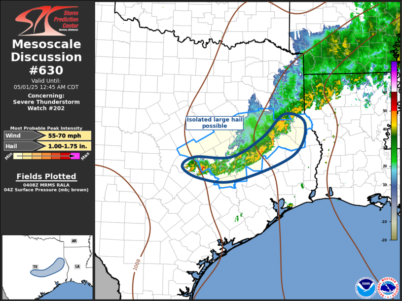
   Mesoscale Discussion 0630
   NWS Storm Prediction Center Norman OK
   1110 PM CDT Wed Apr 30 2025

   Areas affected...Central/East Texas

   Concerning...Severe Thunderstorm Watch 202...

   Valid 010410Z - 010545Z

   The severe weather threat for Severe Thunderstorm Watch 202
   continues.

   SUMMARY...Isolated large hail threat continues with convection this
   evening. Severe threat is expected to gradually wane and a new ww is
   not currently anticipated. However an EXT could be warranted for an
   hour or so.

   DISCUSSION...Southern influence of southern Plains short-wave trough
   appears to be aiding southwestern flank of elongated MCS. Latest
   radar data suggests several robust updrafts continue to generate
   hail, especially over Williamson/Milam County just northeast of
   Austin. This activity is moving slowly southeast as the primary
   synoptic boundary sags into this portion of TX. Isolated large hail
   continues to be the main severe threat with these storms.

   ..Darrow.. 05/01/2025

   ...Please see www.spc.noaa.gov for graphic product...

   ATTN...WFO...LCH...SHV...HGX...FWD...EWX...

   LAT...LON   30859738 30869627 31389533 31999465 31739402 30919439
               30259614 30319723 30599774 30859738

   MOST PROBABLE PEAK WIND GUST...55-70 MPH
   MOST PROBABLE PEAK HAIL SIZE...1.00-1.75 IN
|
|
Top/All Mesoscale Discussions/Forecast Products/Home
|
|


 @NWSSPC