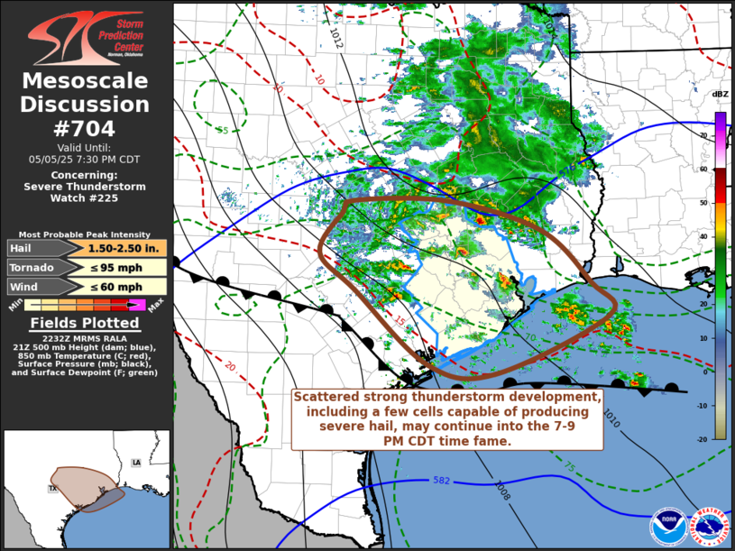
   Mesoscale Discussion 0704
   NWS Storm Prediction Center Norman OK
   0534 PM CDT Mon May 05 2025

   Areas affected...parts of sern TX

   Concerning...Severe Thunderstorm Watch 225...

   Valid 052234Z - 060030Z

   The severe weather threat for Severe Thunderstorm Watch 225
   continues.

   SUMMARY...Scattered strong thunderstorm development will continue
   for several more hours, including few cells which may become capable
   of producing severe hail, before activity weakens later this
   evening.  It is unlikely that a new severe weather watch will be
   needed, but trends will continue to be monitored.

   DISCUSSION...A broad area of convection, rooted within forcing for
   ascent associated with lower/mid-tropospheric warm advection,
   continues to gradually overspread much of eastern/southeastern
   Texas, with scattered embedded thunderstorm activity.  This includes
   more recent vigorous development northwest of Victoria through
   mid/upper Texas coastal areas, in closer proximity to a stalled
   surface frontal zone extending inland of coastal areas, through the
   Texas Hill Country and Edwards Plateau.  The northward edge of the
   stronger convection appears focused along the leading edge of
   southward propagating gravity waves, which may reach the Greater
   Houston and College Station vicinities by 00-01z.  Until then,
   thermodynamic profiles characterized by seasonably moist air,
   surmounted by modestly steep lapse rates, above the frontal
   inversion, may remain supportive of convection capable of producing
   severe hail, aided by strong shear in the convective layer.

   ..Kerr.. 05/05/2025

   ...Please see www.spc.noaa.gov for graphic product...

   ATTN...WFO...LCH...HGX...FWD...CRP...EWX...

   LAT...LON   30879768 30889612 30449458 29689377 29209346 28379536
               28519646 29589766 30119827 30719788 30879768

   MOST PROBABLE PEAK TORNADO INTENSITY...UP TO 95 MPH
   MOST PROBABLE PEAK WIND GUST...UP TO 60 MPH
   MOST PROBABLE PEAK HAIL SIZE...1.50-2.50 IN
|


 @NWSSPC