|
| Mesoscale Discussion 711 |
|
[an error occurred while processing this directive]
|

|
   Mesoscale Discussion 0711
   NWS Storm Prediction Center Norman OK
   0506 AM CDT Tue May 06 2025

   Areas affected...TX Concho Valley into Northwest TX

   Concerning...Severe Thunderstorm Watch 230...

   Valid 061006Z - 061130Z

   The severe weather threat for Severe Thunderstorm Watch 230
   continues.

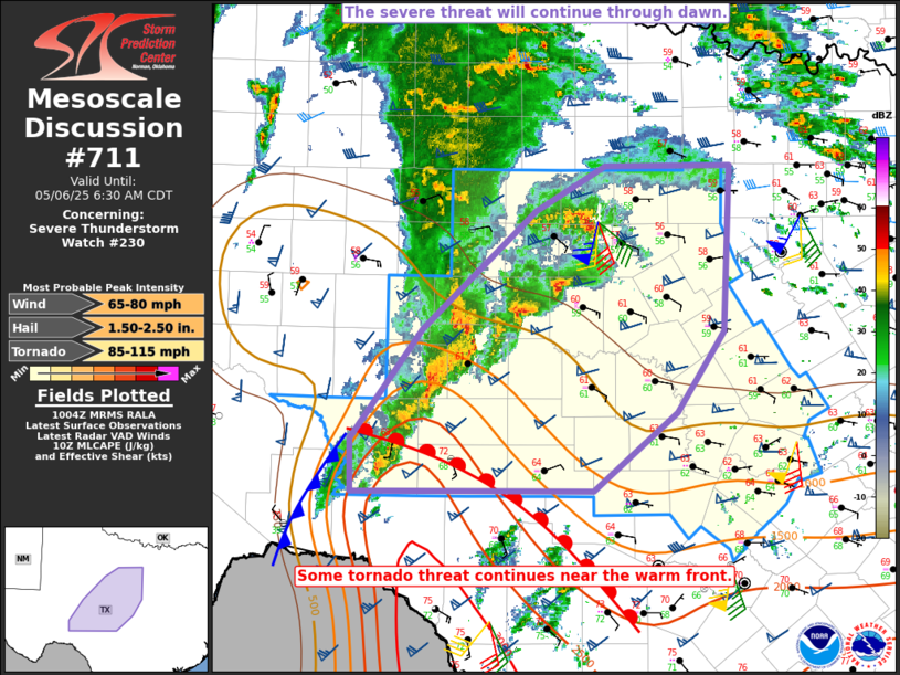
   SUMMARY...The severe threat is expected to continue through dawn,
   with potential for hail and severe gusts. A tornado threat also
   remains near the warm front.

   DISCUSSION...Several strong to potentially severe storms are moving
   east-northeast across the Concho Valley region of TX into the Big
   Country. The bulk of the ongoing convection is elevated to the north
   of a warm front that is gradually moving northward across the
   Edwards Plateau and Hill Country. Moderate buoyancy and strong
   deep-layer shear will continue to support a threat for large to very
   large hail and localized severe gusts with any elevated supercells.
   The line segment that earlier organized along a cold front and is
   now moving through San Angelo could pose a somewhat greater threat
   for strong to severe gusts, in addition to hail with embedded
   supercells.

   Farther southwest, increasing convection has been noted along the
   trailing cold front/outflow into Crockett County, TX. Convection in
   this area is in closer proximity to the warm front and rich surface
   moisture. Low-level hodographs remain sufficiently large to support
   a tornado threat with any discrete or embedded supercell that moves
   within the vicinity of the warm front early this morning.

   ..Dean.. 05/06/2025

   ...Please see www.spc.noaa.gov for graphic product...

   ATTN...WFO...FWD...EWX...SJT...MAF...

   LAT...LON   30740160 31650092 32619985 32999917 32989797 31629805
               30979850 30329929 30310159 30740160

   MOST PROBABLE PEAK TORNADO INTENSITY...85-115 MPH
   MOST PROBABLE PEAK WIND GUST...65-80 MPH
   MOST PROBABLE PEAK HAIL SIZE...1.50-2.50 IN
|
|
Top/All Mesoscale Discussions/Forecast Products/Home
|
|


