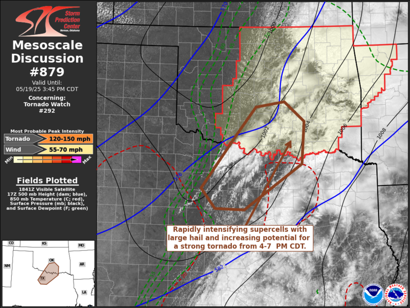
   Mesoscale Discussion 0879
   NWS Storm Prediction Center Norman OK
   0145 PM CDT Mon May 19 2025

   Areas affected...parts of north central Texas into south central
   Oklahoma

   Concerning...Tornado Watch 292...

   Valid 191845Z - 192045Z

   The severe weather threat for Tornado Watch 292 continues.

   SUMMARY...Intensifying supercells increasingly probable through 4-7
   PM CDT, initially posing a risk for large to giant hail, before the
   risk for a couple of strong tornadoes increases toward early
   evening.  A new tornado watch is likely across parts of north
   central Texas.

   DISCUSSION...Even with downward mixing of momentum, within the more
   strongly heated and deeply mixed boundary layer to the west of the
   dryline, west-southwesterly surface gusts remain relatively modest,
   as a significant mid-level trough begins to pivot northeast of the
   southern high plains.  However, as this trough gradually takes on
   more of a negative tilt, strongest mid/upper forcing for ascent
   within its base is forecast to overspread the dryline across the Red
   River vicinity through 21-00Z.

   Sustained intensifying thunderstorm development may now be underway
   along the sharpening dryline to the southwest of Wichita Falls TX.
   This seems likely to persist, as inhibition continues to erode with
   further insolation and cooling aloft.  A notable further increase in
   number of storms seems probable with the forcing for ascent,
   particularly focused south of Chickasha OK into the Mineral Wells TX
   vicinity, before spreading northeastward/eastward.

   Thermodynamic profiles characterized by steep lower/mid-tropospheric
   lapse rates and CAPE approaching 4000 j/kg will probably support a
   few intense supercells, in the presence of strongly sheared 40-50 kt
   southwesterly deep-layer mean flow.  Toward 20/00Z, initially modest
   low-level hodographs may begin to enlarge and become more conducive
   to tornado potential across the Red River vicinity near/east of the
   Ardmore vicinity.

   ..Kerr.. 05/19/2025

   ...Please see www.spc.noaa.gov for graphic product...

   ATTN...WFO...FWD...OUN...SJT...

   LAT...LON   34389814 35019760 35149676 34669616 33609625 32479794
               32519880 33009921 34389814

   MOST PROBABLE PEAK TORNADO INTENSITY...120-150 MPH
   MOST PROBABLE PEAK WIND GUST...55-70 MPH
|


 @NWSSPC