|
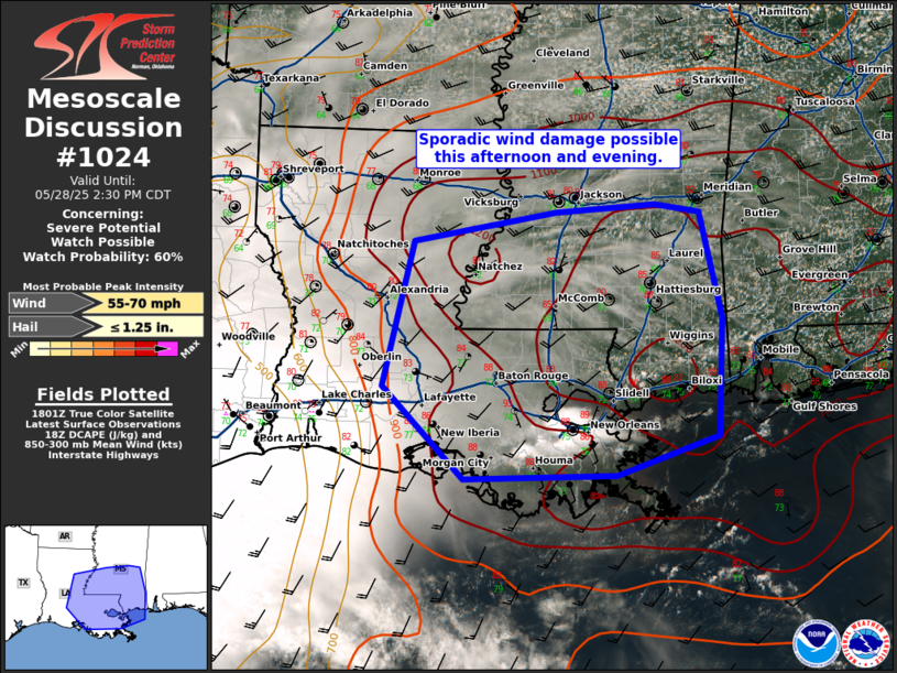
| Mesoscale Discussion 1024 |
|
[an error occurred while processing this directive]
|
|
   Mesoscale Discussion 1024
   NWS Storm Prediction Center Norman OK
   0107 PM CDT Wed May 28 2025

   Areas affected...Southeast Louisiana and southern Mississippi

   Concerning...Severe potential...Watch possible

   Valid 281807Z - 281930Z

   Probability of Watch Issuance...60 percent

   SUMMARY...Sporadic wind damage will be possible from thunderstorms
   this afternoon.

   DISCUSSION...Moderate to strong instability has developed across
   southeast Louisiana and southern Mississippi where temperatures have
   warmed into the upper 80s to low 90s with dewpoints in the low to
   mid 70s. The environment is favorable for strong downdrafts capable
   of some wind damage with DCAPE in excess of 1000 J/kg across much of
   the region. This is already apparent from the KHDC radar where early
   storms across St. Charles and St. John the Baptist Parishes have
   already produced prolific outflow. If enough storms can form to
   generate a stronger northward moving cold pool, a more organized
   damaging wind threat could materialize and necessitate a watch
   across parts of eastern Louisiana and southern Mississippi.

   ..Bentley/Guyer.. 05/28/2025

   ...Please see www.spc.noaa.gov for graphic product...

   ATTN...WFO...MOB...JAN...LIX...LCH...SHV...

   LAT...LON   29918853 29518972 29479152 30409249 31899212 32199043
               32268926 32188874 31108847 29918853

   MOST PROBABLE PEAK WIND GUST...55-70 MPH
   MOST PROBABLE PEAK HAIL SIZE...UP TO 1.25 IN
|
|
Top/All Mesoscale Discussions/Forecast Products/Home
|
|


 @NWSSPC