|
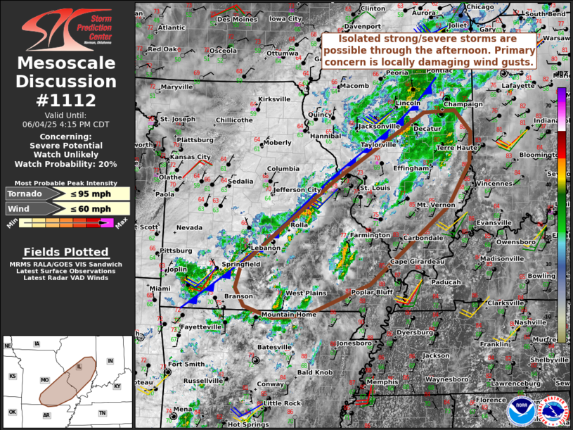
| Mesoscale Discussion 1112 |
|
[an error occurred while processing this directive]
|
|
   Mesoscale Discussion 1112
   NWS Storm Prediction Center Norman OK
   0143 PM CDT Wed Jun 04 2025

   Areas affected...Parts of southeast Missouri into southern/central
   Illinois

   Concerning...Severe potential...Watch unlikely

   Valid 041843Z - 042115Z

   Probability of Watch Issuance...20 percent

   SUMMARY...Isolated strong to severe storms are possible through the
   afternoon. The primary concern is locally damaging wind gusts.

   DISCUSSION...Widely scattered thunderstorms are evolving
   northeastward across southeastern MO -- within a zone of
   differential heating along/ahead of the cold front. Despite poor
   midlevel lapse rates, heating within cloud breaks amid upper
   60s/lower 70s dewpoints is yielding sufficient (albeit weak)
   surface-based instability. While deep-layer shear is modest across
   the region (20-30 kt of effective shear), small, clockwise-curved
   hodographs could still support localized convective organization
   into clusters and transient supercell structures. The primary
   concern is locally damaging wind gusts, especially with any
   localized clustering, though a brief/weak tornado cannot be entirely
   ruled out with any mini supercells that can evolve. Given the
   expected localized nature of the severe threat, a watch is not
   expected.

   ..Weinman/Smith.. 06/04/2025

   ...Please see www.spc.noaa.gov for graphic product...

   ATTN...WFO...IND...PAH...ILX...LSX...LZK...SGF...

   LAT...LON   37299284 38859072 40068867 40088795 39708759 39148763
               38398812 36978992 36439132 36369211 36569275 36899296
               37299284

   MOST PROBABLE PEAK TORNADO INTENSITY...UP TO 95 MPH
   MOST PROBABLE PEAK WIND GUST...UP TO 60 MPH
|
|
Top/All Mesoscale Discussions/Forecast Products/Home
|
|


 @NWSSPC