|
| Mesoscale Discussion 1130 |
|
[an error occurred while processing this directive]
|
|
Mesoscale Discussion 1130
NWS Storm Prediction Center Norman OK
0351 PM CDT Thu Jun 05 2025
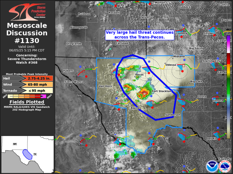
Areas affected...Parts of the Texas Trans-Pecos
Concerning...Severe Thunderstorm Watch 368...
Valid 052051Z - 052215Z
The severe weather threat for Severe Thunderstorm Watch 368
continues.
SUMMARY...Risk of very large hail continues across parts of the
Texas Trans-Pecos.
DISCUSSION...Splitting supercells are ongoing across the TX
Trans-Pecos -- in an environment with long/fairly straight
hodographs (around 40-50 kt of effective shear) and 2000-3000 J/kg
MLCAPE. Given the continued splitting/semi-discrete mode, very large
hail (3+ inches) remains the primary concern. In particular, a
large/persistent supercell cluster undergoing additional storm
merging west of Fort Stockton should pose a risk of very large hail
and severe wind gusts -- especially given recent signs of southward
propagation.
..Weinman.. 06/05/2025
...Please see www.spc.noaa.gov for graphic product...
ATTN...WFO...SJT...MAF...
LAT...LON 30030272 30360331 30920389 31430418 31720414 32010392
32110357 31990317 31580287 30810196 30130209 30030272
MOST PROBABLE PEAK TORNADO INTENSITY...UP TO 95 MPH
MOST PROBABLE PEAK WIND GUST...65-80 MPH
MOST PROBABLE PEAK HAIL SIZE...2.75-4.25 IN
|
|
Top/All Mesoscale Discussions/Forecast Products/Home
|
|


 @NWSSPC