|
| Mesoscale Discussion 1141 |
|
[an error occurred while processing this directive]
|
|
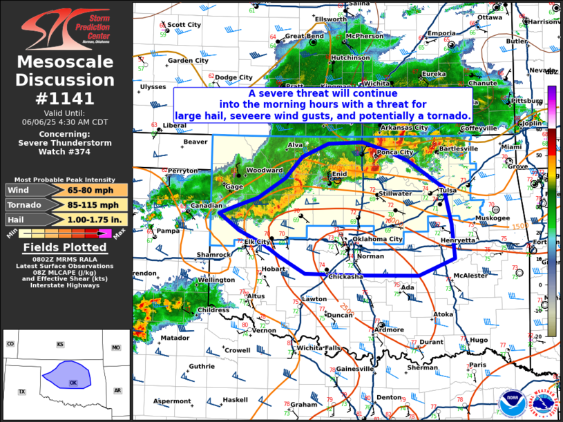
   Mesoscale Discussion 1141
   NWS Storm Prediction Center Norman OK
   0304 AM CDT Fri Jun 06 2025

   Areas affected...northern and central Oklahoma

   Concerning...Severe Thunderstorm Watch 374...

   Valid 060804Z - 060930Z

   The severe weather threat for Severe Thunderstorm Watch 374
   continues.

   SUMMARY...A severe threat will continue into the early morning hours
   with a threat for large hail, severe wind gusts, and potentially a
   tornado.

   DISCUSSION...A well-developed bow echo has developed across
   northwest Oklahoma with strong to occasionally severe wind gusts
   reported. In addition, slower moving storms with embedded supercell
   structures continue east across northern Oklahoma with occasional
   large hail and severe wind gusts reported (including 53 knots at
   KBKN and 62 knots at KPNC). These storms may also pose some tornado
   threat given the favorable storm mode and strengthening low-level
   shear (300+ m2/s2 0-1km SRH per TLX VWP) Downstream of the bow-echo,
   SPC mesoanalysis shows instability has increased with MUCAPE over
   3000 J/kg over central Oklahoma. This increasing instability has
   occurred primarily due to low-level moisture advection (dewpoints
   now in the low 70s) and steepening mid-level lapse rates. Given the
   increased instability across central Oklahoma, expect this line of
   storms to persist and perhaps strengthen over the next few hours.
   Therefore, severe thunderstorm watch 374 may need to be expanded
   south a few rows of counties within the next hour or two, if it
   appears imminent that a severe threat may persist south of the
   current watch.

   ..Bentley/Hart.. 06/06/2025

   ...Please see www.spc.noaa.gov for graphic product...

   ATTN...WFO...TSA...OUN...

   LAT...LON   35889984 35999957 36119917 36399869 36719839 36899793
               36929733 36809692 36649652 36259591 35739577 35259572
               35019635 35029739 35049833 35279878 35449905 35649950
               35889984

   MOST PROBABLE PEAK TORNADO INTENSITY...85-115 MPH
   MOST PROBABLE PEAK WIND GUST...65-80 MPH
   MOST PROBABLE PEAK HAIL SIZE...1.00-1.75 IN
|
|
Top/All Mesoscale Discussions/Forecast Products/Home
|
|


 @NWSSPC