|
| Mesoscale Discussion 1153 |
|
[an error occurred while processing this directive]
|
|
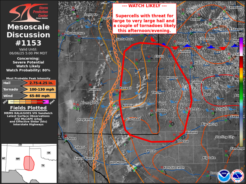
   Mesoscale Discussion 1153
   NWS Storm Prediction Center Norman OK
   0354 PM CDT Fri Jun 06 2025

   Areas affected...eastern New Mexico and portions of Southwestern
   Texas

   Concerning...Severe potential...Watch likely

   Valid 062054Z - 062300Z

   Probability of Watch Issuance...80 percent

   SUMMARY...Supercells capable of large to very large hail, damaging
   winds, and a couple of tornadoes likely this afternoon and evening.

   DISCUSSION...Recent satellite imagery shows deepening cu across the
   dryline and high terrain of eastern New Mexico. Dew points in this
   region are in the upper 50s to 60s with MLCIN slowly eroding across
   far southeastern New Mexico where temperatures are in the 90s.
   Trends would suggest convective initiation may be delayed from
   timing in most CAM guidance but should occur over the next couple of
   hours.

   Strong deep layer shear around 50-55 kts will promote supercells
   initially capable of large to very large hail and damaging wind.
   Through time this evening, storms will be moving into a very
   unstable and strongly sheared air mass across southwestern Texas. As
   the low-level jet strengthens, an increase in hodograph curvature
   and increasing 0-1 km SRH will likely lead to an increase in tornado
   potential. A watch will likely be needed this afternoon/evening to
   cover this threat.

   ..Thornton/Smith.. 06/06/2025

   ...Please see www.spc.noaa.gov for graphic product...

   ATTN...WFO...LUB...AMA...MAF...ABQ...

   LAT...LON   32130427 32570441 33030450 33660444 34610433 34810404
               34890375 34850301 34720265 34140227 33550187 33030180
               32060210 31780252 31770331 31970407 32130427

   MOST PROBABLE PEAK TORNADO INTENSITY...100-130 MPH
   MOST PROBABLE PEAK WIND GUST...65-80 MPH
   MOST PROBABLE PEAK HAIL SIZE...2.75-4.25 IN
|
|
Top/All Mesoscale Discussions/Forecast Products/Home
|
|


 @NWSSPC