|
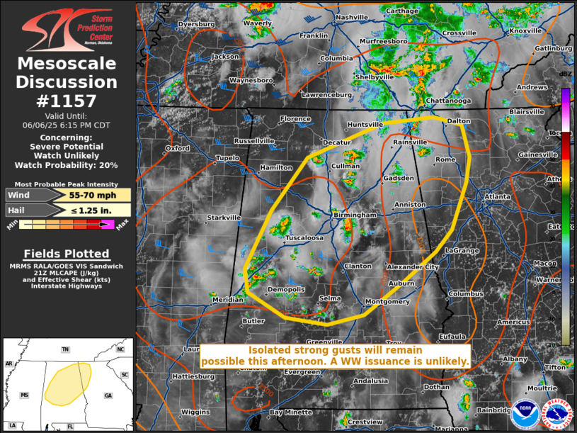
| Mesoscale Discussion 1157 |
|
[an error occurred while processing this directive]
|
|
   Mesoscale Discussion 1157
   NWS Storm Prediction Center Norman OK
   0452 PM CDT Fri Jun 06 2025

   Areas affected...portions of central and northern Alabama into
   northern Georgia

   Concerning...Severe potential...Watch unlikely

   Valid 062152Z - 062315Z

   Probability of Watch Issuance...20 percent

   SUMMARY...A few strong wind gusts will remain possible through the
   rest of the afternoon. Given the isolated nature of the severe
   threat, a WW issuance is not expected.

   DISCUSSION...Several strong pulse-cellular and multicellular storms
   have matured over the past few hours given strong heating of a moist
   boundary layer. 7-8 C/km boundary-layer lapse rates atop 70+ F
   surface dewpoints are contributing to 1500-3000 J/kg MLCAPE. While
   the warm sector is overspread by only 25-35 kts of effective bulk
   shear, these conditions should support continued organization of
   multicells with wet downburst potential. The severe threat, however,
   should be isolated, precluding a WW issuance.

   ..Squitieri/Gleason.. 06/06/2025

   ...Please see www.spc.noaa.gov for graphic product...

   ATTN...WFO...FFC...BMX...HUN...MOB...

   LAT...LON   32218754 32548812 32868817 33638776 34348720 34818599
               34888516 34778470 34358458 34008464 33388488 33098514
               32678568 32258628 32128687 32218754

   MOST PROBABLE PEAK WIND GUST...55-70 MPH
   MOST PROBABLE PEAK HAIL SIZE...UP TO 1.25 IN
|
|
Top/All Mesoscale Discussions/Forecast Products/Home
|
|


 @NWSSPC