|
| Mesoscale Discussion 1221 |
|
[an error occurred while processing this directive]
|
|
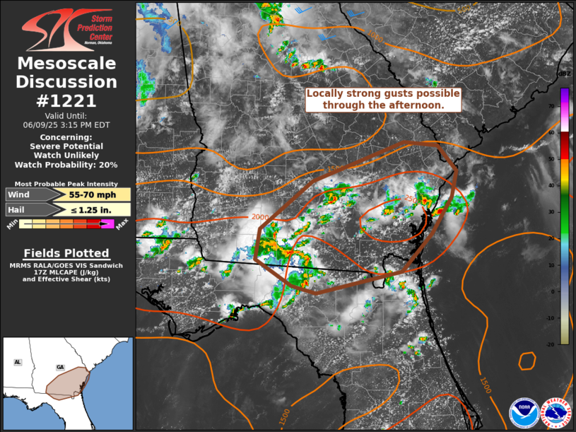
   Mesoscale Discussion 1221
   NWS Storm Prediction Center Norman OK
   1220 PM CDT Mon Jun 09 2025

   Areas affected...portions of north FL and southeast GA

   Concerning...Severe potential...Watch unlikely

   Valid 091720Z - 091915Z

   Probability of Watch Issuance...20 percent

   SUMMARY...Locally strong wind gusts may occur this afternoon with
   thunderstorm activity developing east/northeast across the region.

   DISCUSSION...A cluster of thunderstorms across southern GA has
   occasionally shown near-severe level velocity signatures on radar of
   the past 30 minutes, and a gust to 55 mph was noted in Lowndes
   County GA. This activity is occurring within a moderately unstable
   but weakly sheared environment. Given weak shear, thunderstorms will
   likely remain somewhat disorganized. However, steep low-level lapse
   rates and PW values near 2 inches may support water-loaded
   downdrafts and sporadic strong downburst winds as convection
   develops east/northeast through the afternoon. Overall severe
   potential is expected to remain limited and a watch is not
   anticipated at this time.

   ..Leitman/Mosier.. 06/09/2025

   ...Please see www.spc.noaa.gov for graphic product...

   ATTN...WFO...CHS...JAX...FFC...TAE...

   LAT...LON   31158401 31818316 32358170 32318115 31958085 31598093
               31098125 30578174 30288310 30378349 30748407 31158401

   MOST PROBABLE PEAK WIND GUST...55-70 MPH
   MOST PROBABLE PEAK HAIL SIZE...UP TO 1.25 IN
|
|
Top/All Mesoscale Discussions/Forecast Products/Home
|
|


 @NWSSPC