|
| Mesoscale Discussion 1223 |
|
[an error occurred while processing this directive]
|
|
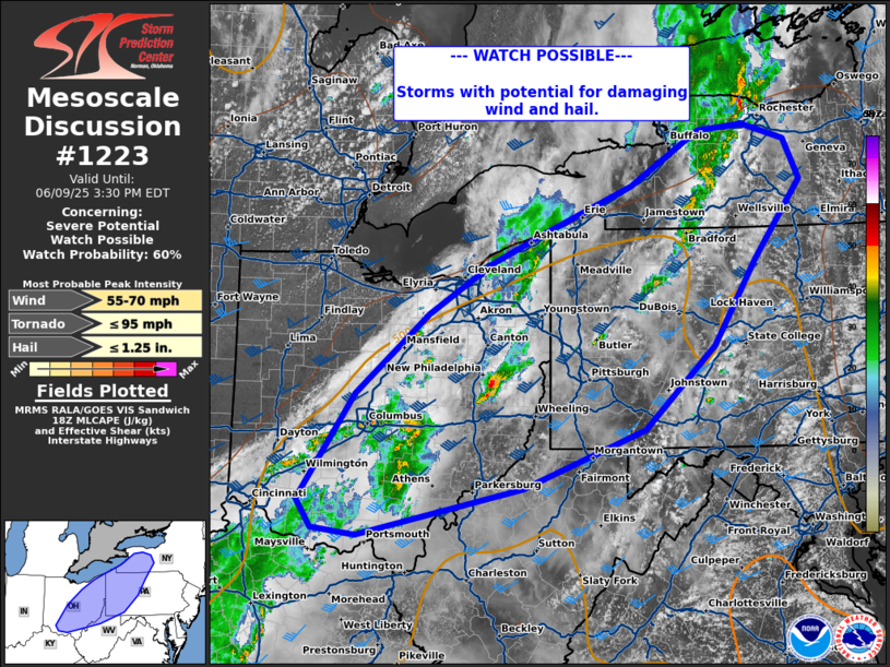
   Mesoscale Discussion 1223
   NWS Storm Prediction Center Norman OK
   0106 PM CDT Mon Jun 09 2025

   Areas affected...eastern Ohio and western Pennsylvania

   Concerning...Severe potential...Watch possible

   Valid 091806Z - 091930Z

   Probability of Watch Issuance...60 percent

   SUMMARY...Thunderstorms capable of damaging wind and hail to
   increase in coverage this afternoon.

   DISCUSSION...Thunderstorms are located across an eastward
   progressing cold front in central OH and western PA. Ahead of the
   front, a few cells have shown some uptick over the last hour. Broken
   cloud cover ahead of the front is allowing pockets of heating, with
   MLCAPE around 500 J/kg. Though thermodynamic profiles are not overly
   favorable, deep layer shear around 30-40 kts with the upper-level
   wave may support organized segments and clusters capable of damaging
   wind and hail. This area will be monitored for watch potential this
   afternoon.

   ..Thornton/Mosier.. 06/09/2025

   ...Please see www.spc.noaa.gov for graphic product...

   ATTN...WFO...BGM...BUF...CTP...PBZ...RLX...CLE...ILN...

   LAT...LON   39168392 40278315 41108216 41648131 41948060 42447940
               43007846 43067783 42917727 42497706 41657770 40787826
               39917923 39298087 38808312 38878372 39168392

   MOST PROBABLE PEAK TORNADO INTENSITY...UP TO 95 MPH
   MOST PROBABLE PEAK WIND GUST...55-70 MPH
   MOST PROBABLE PEAK HAIL SIZE...UP TO 1.25 IN
|
|
Top/All Mesoscale Discussions/Forecast Products/Home
|
|


 @NWSSPC