|
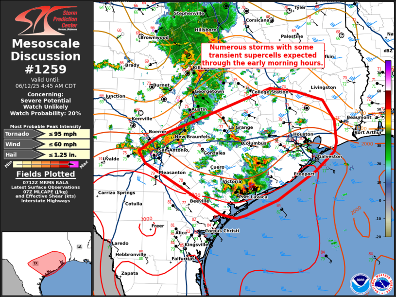
| Mesoscale Discussion 1259 |
|
[an error occurred while processing this directive]
|
|
   Mesoscale Discussion 1259
   NWS Storm Prediction Center Norman OK
   0214 AM CDT Thu Jun 12 2025

   Areas affected...parts of south-central and southeast Texas

   Concerning...Severe potential...Watch unlikely

   Valid 120714Z - 120945Z

   Probability of Watch Issuance...20 percent

   SUMMARY...Numerous storms with some transient supercells expected
   through the early morning hours.

   DISCUSSION...A modest strengthening of a southeasterly low-level jet
   has resulted in widespread storm development across southeast Texas
   over the past hour. Relatively warm temperatures aloft and moist
   conditions through the column should be a limiting factor to large
   hail. However, intense water loading within these updrafts could
   result in some strong downbursts capable of strong to severe wind
   gusts. In addition, small but strongly curved low-level hodographs,
   as sampled by the KHGX VWP, will support some tornado threat. The
   lack of stronger deep-layer shear will likely limit the overall
   threat and thus the need for a watch.

   ..Bentley/Hart.. 06/12/2025

   ...Please see www.spc.noaa.gov for graphic product...

   ATTN...WFO...LCH...HGX...CRP...EWX...

   LAT...LON   28119666 28209701 29219877 29479892 29779845 30069772
               30589638 30769586 30699526 30529464 30099437 29659432
               29479438 29079480 28489569 28259625 28179643 28119666

   MOST PROBABLE PEAK TORNADO INTENSITY...UP TO 95 MPH
   MOST PROBABLE PEAK WIND GUST...UP TO 60 MPH
   MOST PROBABLE PEAK HAIL SIZE...UP TO 1.25 IN
|
|
Top/All Mesoscale Discussions/Forecast Products/Home
|
|


 @NWSSPC