|
| Mesoscale Discussion 1268 |
|
[an error occurred while processing this directive]
|

|
   Mesoscale Discussion 1268
   NWS Storm Prediction Center Norman OK
   0750 PM CDT Thu Jun 12 2025

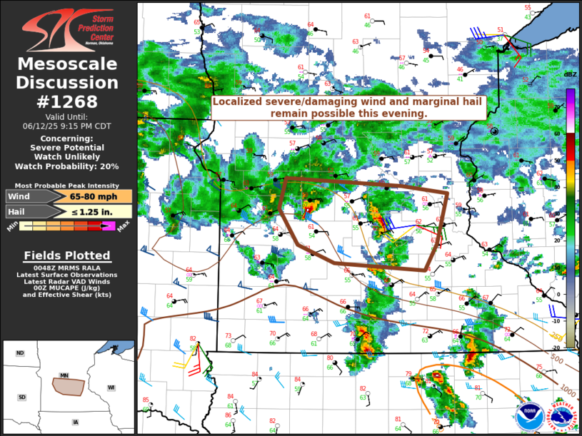
   Areas affected...Parts of south-central MN

   Concerning...Severe potential...Watch unlikely

   Valid 130050Z - 130215Z

   Probability of Watch Issuance...20 percent

   SUMMARY...A threat for localized severe/damaging wind and marginal
   hail remains possible this evening.

   DISCUSSION...An elevated supercell has evolved into a small linear
   segment across parts of south-central MN. Despite its clearly
   elevated nature, this storm produced a 75 kt gust in Hutchinson, MN,
   along with reports of substantial wind damage. The longevity of the
   severe threat with this small line segment is uncertain, given
   decreasing MUCAPE downstream. However, given its current severe
   intensity, some threat could reach at least western portions of the
   Twin Cities area.

   Another small elevated supercell is ongoing upstream across
   southwest MN. Whether or not this cell undergoes a similar evolution
   as the lead cell is highly uncertain, but some threat for isolated
   hail and damaging wind could accompany this storm as well as it
   moves east-southeastward this evening.

   ..Dean/Smith.. 06/13/2025

   ...Please see www.spc.noaa.gov for graphic product...

   ATTN...WFO...MPX...

   LAT...LON   45339547 45269377 45189309 44649324 44379342 44459476
               44649530 45019558 45339547

   MOST PROBABLE PEAK WIND GUST...65-80 MPH
   MOST PROBABLE PEAK HAIL SIZE...UP TO 1.25 IN
|
|
Top/All Mesoscale Discussions/Forecast Products/Home
|
|


