|
| Mesoscale Discussion 1275 |
|
[an error occurred while processing this directive]
|
|
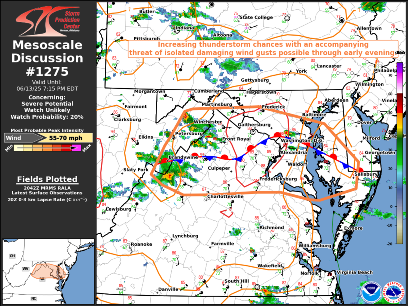
   Mesoscale Discussion 1275
   NWS Storm Prediction Center Norman OK
   0343 PM CDT Fri Jun 13 2025

   Areas affected...Northern Virginia...Maryland...and the D.C. Metro

   Concerning...Severe potential...Watch unlikely

   Valid 132043Z - 132315Z

   Probability of Watch Issuance...20 percent

   SUMMARY...Thunderstorm chances will continue to increase through
   early this evening across portions of northern VA and MD. A threat
   of localized damaging wind gusts exceeding 60 mph appears possible.

   DISCUSSION...The latest visible satellite and radar imagery suggest
   moist convection is beginning to deepen near a stationary boundary
   draped west to east across northern VA and central MD, with ongoing
   thunderstorms beginning to move eastward off the higher terrain.
   This boundary will remain a focus for thunderstorm development
   through early this evening as a very subtle mid-level shortwave
   perturbation approaches from the west, although thunderstorm
   coverage should generally remain at or below 40%. Daytime heating
   this afternoon, combined with a moist boundary layer, are
   contributing to a north-to-south axis of low to moderate instability
   nudging into the DC Metro. Although weaker flow aloft should limit
   overall thunderstorm organization, steep low-level lapse rates of
   8-8.5 C/km and DCAPE ~1300 J/kg could support an isolated damaging
   downburst or two. Given the isolated nature of the threat, a severe
   weather watch is not expected at this time.

   ..Barnes/Thompson.. 06/13/2025

   ...Please see www.spc.noaa.gov for graphic product...

   ATTN...WFO...PHI...AKQ...LWX...

   LAT...LON   39387892 38997918 38857930 38417956 38257933 38107891
               38117830 38157749 38157703 38027645 38017625 38197554
               38607549 39207615 39477745 39427876 39387892

   MOST PROBABLE PEAK WIND GUST...55-70 MPH
|
|
Top/All Mesoscale Discussions/Forecast Products/Home
|
|


 @NWSSPC