|
| Mesoscale Discussion 1284 |
|
[an error occurred while processing this directive]
|

|
   Mesoscale Discussion 1284
   NWS Storm Prediction Center Norman OK
   1116 AM CDT Sat Jun 14 2025

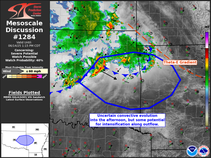
   Areas affected...East-central Oklahoma into west-central Arkansas

   Concerning...Severe potential...Watch possible

   Valid 141616Z - 141815Z

   Probability of Watch Issuance...40 percent

   SUMMARY...Isolated damaging winds are possible with a cluster of
   storms moving towards east-central/southeast Oklahoma. Convective
   trends in storm organization will need to be monitored.

   DISCUSSION...As the low-level jet has diminished in intensity this
   morning, convection in northeast Oklahoma has had outflow outpace
   the stronger updrafts. While the 12Z observed sounding from Little
   Rock showed poor lapse rates aloft, modifying the sounding with
   current surface observation suggests around 2000 J/kg MLCAPE.
   Recently, storms have developed near the intersection of two outflow
   boundaries south-southwest of Tulsa. Given the improvement in
   low-level lapse rates into the afternoon downstream of this
   activity, There is some potential for continued intensification.
   Overall, tropospheric flow is rather weak. Organization of activity
   will be largely dependent on cold pool dynamics as well as storms
   not being undercut by outflow to the northeast. Damaging wind gusts
   are possible at least on an isolated basis. The need for a watch is
   uncertain. Observational/convective trends will need to be monitored
   over the next few hours.

   ..Wendt/Thompson.. 06/14/2025

   ...Please see www.spc.noaa.gov for graphic product...

   ATTN...WFO...LZK...SHV...TSA...OUN...

   LAT...LON   36199393 35819313 35349283 34839320 34409410 34369485
               34599587 35259694 36089613 36289474 36199393

   MOST PROBABLE PEAK WIND GUST...UP TO 60 MPH
|
|
Top/All Mesoscale Discussions/Forecast Products/Home
|
|


