|
| Mesoscale Discussion 1313 |
|
[an error occurred while processing this directive]
|

|
   Mesoscale Discussion 1313
   NWS Storm Prediction Center Norman OK
   0253 PM CDT Mon Jun 16 2025

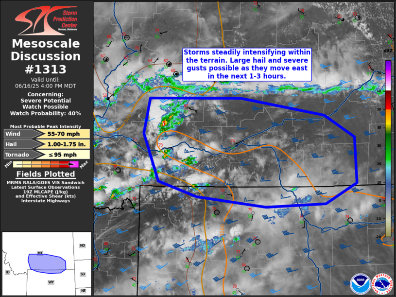
   Areas affected...Parts of southern Montana into far northern Wyoming

   Concerning...Severe potential...Watch possible

   Valid 161953Z - 162200Z

   Probability of Watch Issuance...40 percent

   SUMMARY...Widely scattered storms are possible southern
   Montana/northern Wyoming. Supercells capable of large hail and
   severe winds are expected. Though timing is uncertain, a watch is
   possible this afternoon.

   DISCUSSION...Modestly moist upslope flow and an approaching
   mid-level trough have promoted thunderstorm development within the
   terrain of south-central Montana. This has occurred north of a band
   of cirrus over much of Wyoming. While these storms have been slow to
   intensify, continued surface heating this afternoon will increase
   MLCAPE values to over 1000 J/kg. Effective shear of 45-55 kts will
   help to organize convection into supercells capable of large hail
   and severe wind gusts. Even with the approaching trough, mid-level
   height falls will generally remain neutral until later in the
   evening. It is not clear what storm coverage will be, but at least
   widely scattered storms are possible with additional development
   occurring in northern Wyoming near the Big Horns. Another point of
   uncertainty is how far south/east activity will go given greater
   inhibition underneath the cirrus canopy.

   ..Wendt/Hart.. 06/16/2025

   ...Please see www.spc.noaa.gov for graphic product...

   ATTN...WFO...UNR...BYZ...RIW...TFX...

   LAT...LON   45971100 46631084 46660839 46330614 45910534 45040531
               44800586 44670615 44620772 44800955 45091058 45971100

   MOST PROBABLE PEAK TORNADO INTENSITY...UP TO 95 MPH
   MOST PROBABLE PEAK WIND GUST...55-70 MPH
   MOST PROBABLE PEAK HAIL SIZE...1.00-1.75 IN
|
|
Top/All Mesoscale Discussions/Forecast Products/Home
|
|


