|
| Mesoscale Discussion 1377 |
|
[an error occurred while processing this directive]
|
|
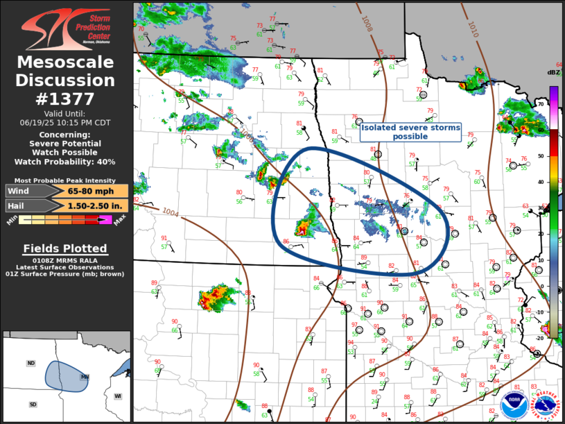
   Mesoscale Discussion 1377
   NWS Storm Prediction Center Norman OK
   0809 PM CDT Thu Jun 19 2025

   Areas affected...Southeast North Dakota and northwest Minnesota

   Concerning...Severe potential...Watch possible

   Valid 200109Z - 200315Z

   Probability of Watch Issuance...40 percent

   SUMMARY...Isolated severe thunderstorms are possible across
   southeastern ND into northwestern MN this evening. Storm coverage
   should increase later this evening. Hail and wind are possible.

   DISCUSSION...Surface boundary is currently draped from central MN
   into southeast ND. Modest 1km flow is impinging on this boundary and
   an elongated corridor of low-level warm advection will hold across
   this region much of tonight. Isolated severe thunderstorms are
   currently noted across this region, but storm coverage should
   increase late this evening as a weak short-wave trough tops the
   ridge and digs southeast toward MN. In response, LLJ should increase
   markedly by 06z across NE into eastern SD/southwestern MN and
   convection should increase across this corridor. Unless ongoing
   activity increases in areal coverage over the next hour or so, will
   likely hold off on issuing a new severe thunderstorm watch until
   stronger large-scale support affects this region.

   ..Darrow/Smith.. 06/20/2025

   ...Please see www.spc.noaa.gov for graphic product...

   ATTN...WFO...DLH...MPX...FGF...ABR...

   LAT...LON   47679730 46739442 45819499 46249787 47679730

   MOST PROBABLE PEAK WIND GUST...65-80 MPH
   MOST PROBABLE PEAK HAIL SIZE...1.50-2.50 IN
|
|
Top/All Mesoscale Discussions/Forecast Products/Home
|
|


 @NWSSPC