|
| Mesoscale Discussion 1419 |
|
[an error occurred while processing this directive]
|
|
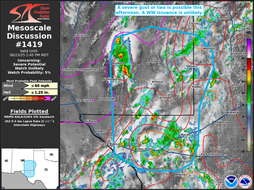
   Mesoscale Discussion 1419
   NWS Storm Prediction Center Norman OK
   0318 PM CDT Mon Jun 23 2025

   Areas affected...portions of southeastern New Mexico into far west
   Texas

   Concerning...Severe potential...Watch unlikely

   Valid 232018Z - 232045Z

   Probability of Watch Issuance...5 percent

   SUMMARY...A severe gust or two cannot be ruled out this afternoon.
   The sparse severe threat should preclude a Severe Thunderstorm Watch
   issuance.

   DISCUSSION...MRMS mosaic radar imagery depicts intensifying
   thunderstorm updrafts, with 40 dBZ cores reaching the 30-50 kft
   range. Boundary layer lapse rates continue to steepen to 9 C/km (per
   20Z mesoanalysis) given strong surface heating. As such, one of the
   stronger storm cores could collapse and produce a severe gust.
   However, vertical wind shear is weak, and pulse-cellular storms
   should remain the primary storm mode. As such, the severe threat is
   low, and a WW issuance is not expected.

   ..Squitieri/Thompson.. 06/23/2025

   ...Please see www.spc.noaa.gov for graphic product...

   ATTN...WFO...LUB...MAF...ABQ...EPZ...

   LAT...LON   30940554 33480572 34070557 34380443 34150294 33690243
               33260240 32230288 31180295 30700315 30510356 30540475
               30940554

   MOST PROBABLE PEAK WIND GUST...UP TO 60 MPH
   MOST PROBABLE PEAK HAIL SIZE...UP TO 1.25 IN
|
|
Top/All Mesoscale Discussions/Forecast Products/Home
|
|


 @NWSSPC