|
| Mesoscale Discussion 1428 |
|
[an error occurred while processing this directive]
|

|
   Mesoscale Discussion 1428
   NWS Storm Prediction Center Norman OK
   0204 PM CDT Tue Jun 24 2025

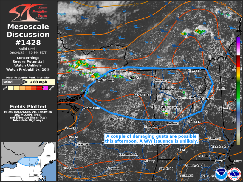
   Areas affected...Portions of northern New York into northern Vermont
   and far northern New Hampshire

   Concerning...Severe potential...Watch unlikely

   Valid 241904Z - 242030Z

   Probability of Watch Issuance...20 percent

   SUMMARY...A couple of damaging gusts may occur across portions of
   northern New England this afternoon. Given the expected limited
   coverage of severe gusts, a Severe Thunderstorm Watch is not
   currently anticipated.

   DISCUSSION...Continued strong diurnal heating is supporting a
   general agitation of a cumulus field over northern New England, with
   recent thunderstorm initiation noted across extreme southeast
   Ontario. Here, surface temperatures are around 90 F amid near 70 F
   surface dewpoints, supporting over 2000 J/kg MLCAPE in spots. These
   storms are initiating along the periphery of the upper-level ridge,
   where modest mid-level flow is supporting 25-30 kts of effective
   bulk shear. As such, the strongest storms may become multicells
   capable of producing a couple of strong to perhaps damaging wind
   gusts. The severe threat should be quite limited, so a WW issuance
   is not currently expected.

   ..Squitieri/Hart.. 06/24/2025

   ...Please see www.spc.noaa.gov for graphic product...

   ATTN...WFO...GYX...BTV...ALY...BUF...

   LAT...LON   44337584 44577572 44827531 44987497 45077434 45047299
               45067177 45037158 44997152 44657131 43957173 43727255
               43767402 43917492 44147551 44337584

   MOST PROBABLE PEAK WIND GUST...UP TO 60 MPH
|
|
Top/All Mesoscale Discussions/Forecast Products/Home
|
|


