|
| Mesoscale Discussion 1439 |
|
[an error occurred while processing this directive]
|

|
   Mesoscale Discussion 1439
   NWS Storm Prediction Center Norman OK
   0340 PM CDT Wed Jun 25 2025

   Areas affected...Parts of the Carolinas into northeast GA

   Concerning...Severe Thunderstorm Watch 459...

   Valid 252040Z - 252215Z

   The severe weather threat for Severe Thunderstorm Watch 459
   continues.

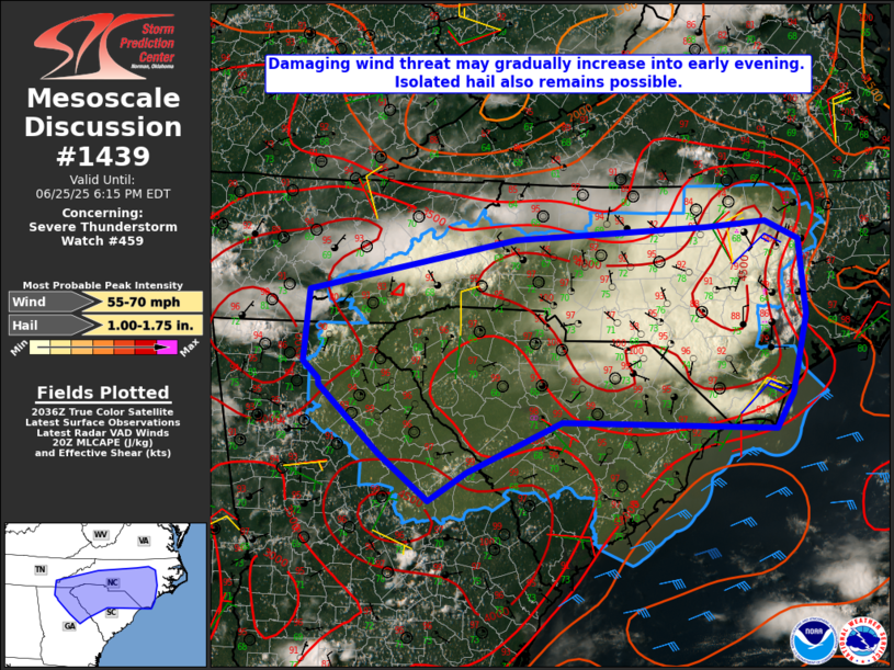
   SUMMARY...The damaging wind threat may gradually increase into the
   early evening. Isolated hail also remains possible.

   DISCUSSION...Extensive convection is ongoing late this afternoon
   across parts of eastern NC, with additional storms in western NC,
   and developing cumulus into parts of SC and east-central/northeast
   GA. Additional storm development is possible into early evening,
   within a very unstable (MLCAPE of 3000-4000 J/kg) environment.
   Generally weak deep-layer shear continue to hamper storm
   organization, but the strong instability and steep midlevel lapse
   rates will continue to support vigorous updrafts.

   Outflow is gradually expanding across eastern NC, and there may be
   some tendency for a loosely organized storm cluster to propagate
   south/southwestward with time, as outflow impinges upon a hot and
   very moist environment. A similar evolution could take place with
   ongoing storms across western NC. This could lead to more
   concentrated areas of damaging wind with time. The strongest
   updrafts will also continue to be capable of producing isolated
   hail.

   ..Dean.. 06/25/2025

   ...Please see www.spc.noaa.gov for graphic product...

   ATTN...WFO...MHX...RAH...ILM...CAE...GSP...MRX...FFC...

   LAT...LON   35358427 35948145 36087886 36137804 35937759 35077750
               34197771 33817794 33898083 33338212 33008263 33528330
               34298412 34368414 34558434 35358427

   MOST PROBABLE PEAK WIND GUST...55-70 MPH
   MOST PROBABLE PEAK HAIL SIZE...1.00-1.75 IN
|
|
Top/All Mesoscale Discussions/Forecast Products/Home
|
|


