|
| Mesoscale Discussion 729 |
|
[an error occurred while processing this directive]
|
|
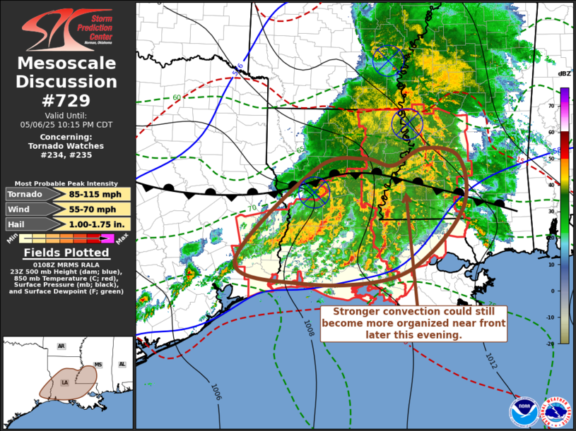
   Mesoscale Discussion 0729
   NWS Storm Prediction Center Norman OK
   0810 PM CDT Tue May 06 2025

   Areas affected...in parts of sern TX...cntrl and srn LA...swrn MS

   Concerning...Tornado Watch 234...235...

   Valid 070110Z - 070315Z

   The severe weather threat for Tornado Watch 234, 235 continues.

   SUMMARY...Strong convection, embedded within a broader area of
   thunderstorm activity, could still gradually organize this evening
   across parts of central Louisiana into southwestern and south
   central Louisiana. Although uncertain, it is possible Tornado Watch
   234 will be allowed to expire as scheduled at 02Z.

   DISCUSSION...Although the primary surface baroclinic zone remains
   stalled across central Louisiana through southern Mississippi,
   consolidating convective development across much of southern into
   central Louisiana and southwestern Mississippi has primarily remain
   rooted within lift associated with warm advection, above the
   seasonably moist boundary layer.  This idea is supported by 07/00Z
   raobs from Lake Charles and Slidell.

   If lift of boundary-layer parcels through at least weak inhibition
   evident in the 850-700 mb layer could be sustained, the environment
   still appears supportive of supercells with the conditional risk of
   a strong tornado.  However, this is appearing less likely with time.
    It still might not be out of the question that stronger convection
   could gradually organize over the next few hours, particularly close
   to the frontal zone across southwestern/south central Mississippi.
   This could result in another developing mesoscale convective vortex,
   perhaps accompanied by increasing potential for strong to severe
   surface gusts.

   ..Kerr.. 05/07/2025

   ...Please see www.spc.noaa.gov for graphic product...

   ATTN...WFO...JAN...LIX...LCH...SHV...HGX...

   LAT...LON   31909299 32119194 31979134 32289068 32138993 31278982
               30379055 29909148 29829318 30209465 31909299

   MOST PROBABLE PEAK TORNADO INTENSITY...85-115 MPH
   MOST PROBABLE PEAK WIND GUST...55-70 MPH
   MOST PROBABLE PEAK HAIL SIZE...1.00-1.75 IN
|
|
Top/All Mesoscale Discussions/Forecast Products/Home
|
|


 @NWSSPC