Note:
The expiration time in the watch graphic is amended if the watch is
replaced, cancelled or extended.
Note:
Note:
The expiration time in the watch graphic is amended if the watch is
replaced, cancelled or extended.
Note: Click for
Watch Status Reports.
   SEL3

   URGENT - IMMEDIATE BROADCAST REQUESTED
   Tornado Watch Number 303
   NWS Storm Prediction Center Norman OK
   110 PM CDT Tue May 20 2025

   The NWS Storm Prediction Center has issued a

   * Tornado Watch for portions of
     Eastern Arkansas
     Southern Illinois
     Western Kentucky
     Southeast Missouri
     Northern Mississippi
     West Tennessee

   * Effective this Tuesday afternoon and evening from 110 PM until
     800 PM CDT.

   * Primary threats include...
     A few tornadoes likely with a couple intense tornadoes possible
     Scattered large hail and isolated very large hail events to 2.5
       inches in diameter likely
     Scattered damaging wind gusts to 70 mph likely

   SUMMARY...Thunderstorms will intensify across the watch area this
   afternoon in a very moist and unstable air mass.  A few supercells
   are expected, capable of large hail, damaging winds, and a few
   tornadoes.

   The tornado watch area is approximately along and 110 statute miles
   east and west of a line from 60 miles east northeast of Poplar Bluff
   MO to 35 miles south of Greenville MS. For a complete depiction of
   the watch see the associated watch outline update (WOUS64 KWNS
   WOU3).

   PRECAUTIONARY/PREPAREDNESS ACTIONS...

   REMEMBER...A Tornado Watch means conditions are favorable for
   tornadoes and severe thunderstorms in and close to the watch
   area. Persons in these areas should be on the lookout for
   threatening weather conditions and listen for later statements
   and possible warnings.

   &&

   OTHER WATCH INFORMATION...CONTINUE...WW 302...

   AVIATION...Tornadoes and a few severe thunderstorms with hail
   surface and aloft to 2.5 inches. Extreme turbulence and surface wind
   gusts to 60 knots. A few cumulonimbi with maximum tops to 500. Mean
   storm motion vector 24030.

   ...Hart
 Note:
The Aviation Watch (SAW) product is an approximation to the watch area.
The actual watch is depicted by the shaded areas.
Note:
The Aviation Watch (SAW) product is an approximation to the watch area.
The actual watch is depicted by the shaded areas.
   SAW3
   WW 303 TORNADO AR IL KY MO MS TN 201810Z - 210100Z
   AXIS..110 STATUTE MILES EAST AND WEST OF LINE..
   60ENE POF/POPLAR BLUFF MO/ - 35S GLH/GREENVILLE MS/
   ..AVIATION COORDS.. 95NM E/W /50SE FAM - 46SW SQS/
   HAIL SURFACE AND ALOFT..2.5 INCHES. WIND GUSTS..60 KNOTS.
   MAX TOPS TO 500. MEAN STORM MOTION VECTOR 24030.

   LAT...LON 37088747 32958908 32959288 37089146

   THIS IS AN APPROXIMATION TO THE WATCH AREA.  FOR A
   COMPLETE DEPICTION OF THE WATCH SEE WOUS64 KWNS
   FOR WOU3.
Watch 303 Status Report Messages:
STATUS REPORT #5 ON WW 303
VALID 202340Z - 210040Z
SEVERE WEATHER THREAT CONTINUES RIGHT OF A LINE FROM 10 NE CBM TO
25 N GWO TO 35 SE MKL TO 35 SSW CKV.
..BROYLES..05/20/25
ATTN...WFO...LZK...JAN...MEG...PAH...
&&
STATUS REPORT FOR WT 303
SEVERE WEATHER THREAT CONTINUES FOR THE FOLLOWING AREAS
MSC003-013-017-057-071-081-095-115-117-139-141-145-161-210040-
MS
. MISSISSIPPI COUNTIES INCLUDED ARE
ALCORN CALHOUN CHICKASAW
ITAWAMBA LAFAYETTE LEE
MONROE PONTOTOC PRENTISS
TIPPAH TISHOMINGO UNION
YALOBUSHA
$$
TNC039-071-109-210040-
TN
. TENNESSEE COUNTIES INCLUDED ARE
DECATUR HARDIN MCNAIRY
$$
THE WATCH STATUS MESSAGE IS FOR GUIDANCE PURPOSES ONLY. PLEASE
REFER TO WATCH COUNTY NOTIFICATION STATEMENTS FOR OFFICIAL
INFORMATION ON COUNTIES...INDEPENDENT CITIES AND MARINE ZONES
CLEARED FROM SEVERE THUNDERSTORM AND TORNADO WATCHES.
$$
STATUS REPORT #4 ON WW 303
VALID 202255Z - 202340Z
SEVERE WEATHER THREAT CONTINUES RIGHT OF A LINE FROM 30 NNE MLU
TO 40 NNE UOX TO 5 NNW MKL TO 5 NW HOP AND 25 NNW MLU TO 15 E MEM
TO 15 S DYR TO 35 SSW CKV.
..BROYLES..05/20/25
ATTN...WFO...LZK...JAN...MEG...PAH...
&&
STATUS REPORT FOR WT 303
SEVERE WEATHER THREAT CONTINUES FOR THE FOLLOWING AREAS
ARC003-017-202340-
AR
. ARKANSAS COUNTIES INCLUDED ARE
ASHLEY CHICOT
$$
MSC003-009-011-013-017-057-071-081-093-095-107-115-117-119-135-
137-139-141-145-161-202340-
MS
. MISSISSIPPI COUNTIES INCLUDED ARE
ALCORN BENTON BOLIVAR
CALHOUN CHICKASAW ITAWAMBA
LAFAYETTE LEE MARSHALL
MONROE PANOLA PONTOTOC
PRENTISS QUITMAN TALLAHATCHIE
TATE TIPPAH TISHOMINGO
UNION YALOBUSHA
$$
TNC005-017-023-033-039-047-069-071-075-077-109-113-202340-
TN
. TENNESSEE COUNTIES INCLUDED ARE
BENTON CARROLL CHESTER
CROCKETT DECATUR FAYETTE
HARDEMAN HARDIN HAYWOOD
HENDERSON MCNAIRY MADISON
$$
THE WATCH STATUS MESSAGE IS FOR GUIDANCE PURPOSES ONLY. PLEASE
REFER TO WATCH COUNTY NOTIFICATION STATEMENTS FOR OFFICIAL
INFORMATION ON COUNTIES...INDEPENDENT CITIES AND MARINE ZONES
CLEARED FROM SEVERE THUNDERSTORM AND TORNADO WATCHES.
$$
STATUS REPORT #3 ON WW 303
VALID 202155Z - 202240Z
SEVERE WEATHER THREAT CONTINUES RIGHT OF A LINE FROM 15 SSW ELD
TO 20 ESE LLQ TO 35 WSW MKL TO 50 SSE PAH TO 40 NNW HOP.
..SQUITIERI..05/20/25
ATTN...WFO...LZK...JAN...MEG...PAH...
&&
STATUS REPORT FOR WT 303
SEVERE WEATHER THREAT CONTINUES FOR THE FOLLOWING AREAS
ARC003-017-202240-
AR
. ARKANSAS COUNTIES INCLUDED ARE
ASHLEY CHICOT
$$
MSC003-009-011-013-015-017-027-033-043-051-053-057-071-081-083-
093-095-097-107-115-117-119-133-135-137-139-141-145-151-155-161-
202240-
MS
. MISSISSIPPI COUNTIES INCLUDED ARE
ALCORN BENTON BOLIVAR
CALHOUN CARROLL CHICKASAW
COAHOMA DESOTO GRENADA
HOLMES HUMPHREYS ITAWAMBA
LAFAYETTE LEE LEFLORE
MARSHALL MONROE MONTGOMERY
PANOLA PONTOTOC PRENTISS
QUITMAN SUNFLOWER TALLAHATCHIE
TATE TIPPAH TISHOMINGO
UNION WASHINGTON WEBSTER
YALOBUSHA
$$
TNC005-017-023-033-039-047-069-071-075-077-079-109-113-167-
202240-
TN
. TENNESSEE COUNTIES INCLUDED ARE
BENTON CARROLL CHESTER
CROCKETT DECATUR FAYETTE
HARDEMAN HARDIN HAYWOOD
HENDERSON HENRY MCNAIRY
MADISON TIPTON
$$
THE WATCH STATUS MESSAGE IS FOR GUIDANCE PURPOSES ONLY. PLEASE
REFER TO WATCH COUNTY NOTIFICATION STATEMENTS FOR OFFICIAL
INFORMATION ON COUNTIES...INDEPENDENT CITIES AND MARINE ZONES
CLEARED FROM SEVERE THUNDERSTORM AND TORNADO WATCHES.
$$
STATUS REPORT #2 ON WW 303
VALID 202040Z - 202140Z
SEVERE WEATHER THREAT CONTINUES RIGHT OF A LINE FROM 30 WNW ELD
TO 40 WSW MEM TO 25 SSE FAM.
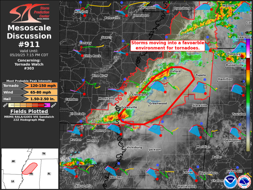
FOR ADDITIONAL INFORMATION SEE MESOSCALE DISCUSSION 908
..MOORE..05/20/25
ATTN...WFO...LZK...JAN...MEG...PAH...
&&
STATUS REPORT FOR WT 303
SEVERE WEATHER THREAT CONTINUES FOR THE FOLLOWING AREAS
ARC001-003-011-013-017-021-035-041-043-079-093-107-202140-
AR
. ARKANSAS COUNTIES INCLUDED ARE
ARKANSAS ASHLEY BRADLEY
CALHOUN CHICOT CLAY
CRITTENDEN DESHA DREW
LINCOLN MISSISSIPPI PHILLIPS
$$
ILC003-087-127-151-153-181-202140-
IL
. ILLINOIS COUNTIES INCLUDED ARE
ALEXANDER JOHNSON MASSAC
POPE PULASKI UNION
$$
KYC007-035-039-075-083-105-139-145-157-202140-
KY
. KENTUCKY COUNTIES INCLUDED ARE
BALLARD CALLOWAY CARLISLE
FULTON GRAVES HICKMAN
LIVINGSTON MCCRACKEN MARSHALL
$$
MSC003-009-011-013-015-017-027-033-043-051-053-057-071-081-083-
093-095-097-107-115-117-119-133-135-137-139-141-143-145-151-155-
161-202140-
MS
. MISSISSIPPI COUNTIES INCLUDED ARE
ALCORN BENTON BOLIVAR
CALHOUN CARROLL CHICKASAW
COAHOMA DESOTO GRENADA
HOLMES HUMPHREYS ITAWAMBA
LAFAYETTE LEE LEFLORE
MARSHALL MONROE MONTGOMERY
PANOLA PONTOTOC PRENTISS
QUITMAN SUNFLOWER TALLAHATCHIE
TATE TIPPAH TISHOMINGO
TUNICA UNION WASHINGTON
WEBSTER YALOBUSHA
$$
MOC017-031-069-133-143-155-201-207-202140-
MO
. MISSOURI COUNTIES INCLUDED ARE
BOLLINGER CAPE GIRARDEAU DUNKLIN
MISSISSIPPI NEW MADRID PEMISCOT
SCOTT STODDARD
$$
TNC005-017-023-033-039-045-047-053-069-071-075-077-079-095-097-
109-113-131-157-167-183-202140-
TN
. TENNESSEE COUNTIES INCLUDED ARE
BENTON CARROLL CHESTER
CROCKETT DECATUR DYER
FAYETTE GIBSON HARDEMAN
HARDIN HAYWOOD HENDERSON
HENRY LAKE LAUDERDALE
MCNAIRY MADISON OBION
SHELBY TIPTON WEAKLEY
$$
THE WATCH STATUS MESSAGE IS FOR GUIDANCE PURPOSES ONLY. PLEASE
REFER TO WATCH COUNTY NOTIFICATION STATEMENTS FOR OFFICIAL
INFORMATION ON COUNTIES...INDEPENDENT CITIES AND MARINE ZONES
CLEARED FROM SEVERE THUNDERSTORM AND TORNADO WATCHES.
$$
STATUS REPORT #1 ON WW 303
VALID 202000Z - 202140Z
SEVERE WEATHER THREAT CONTINUES RIGHT OF A LINE FROM 45 NW ELD TO
40 WSW PBF TO 45 E LIT TO 30 E UNO.
..MOORE..05/20/25
ATTN...WFO...LZK...JAN...MEG...PAH...
&&
STATUS REPORT FOR WT 303
SEVERE WEATHER THREAT CONTINUES FOR THE FOLLOWING AREAS
ARC001-003-011-013-017-021-025-031-035-037-041-043-055-067-069-
075-077-079-093-095-103-107-111-121-123-147-202140-
AR
. ARKANSAS COUNTIES INCLUDED ARE
ARKANSAS ASHLEY BRADLEY
CALHOUN CHICOT CLAY
CLEVELAND CRAIGHEAD CRITTENDEN
CROSS DESHA DREW
GREENE JACKSON JEFFERSON
LAWRENCE LEE LINCOLN
MISSISSIPPI MONROE OUACHITA
PHILLIPS POINSETT RANDOLPH
ST. FRANCIS WOODRUFF
$$
ILC003-087-127-151-153-181-202140-
IL
. ILLINOIS COUNTIES INCLUDED ARE
ALEXANDER JOHNSON MASSAC
POPE PULASKI UNION
$$
KYC007-035-039-075-083-105-139-145-157-202140-
KY
. KENTUCKY COUNTIES INCLUDED ARE
BALLARD CALLOWAY CARLISLE
FULTON GRAVES HICKMAN
LIVINGSTON MCCRACKEN MARSHALL
$$
MSC003-009-011-013-015-017-027-033-043-051-053-057-071-081-083-
093-095-097-107-115-117-119-133-135-137-139-141-143-145-151-155-
161-202140-
MS
. MISSISSIPPI COUNTIES INCLUDED ARE
ALCORN BENTON BOLIVAR
CALHOUN CARROLL CHICKASAW
COAHOMA DESOTO GRENADA
HOLMES HUMPHREYS ITAWAMBA
LAFAYETTE LEE LEFLORE
MARSHALL MONROE MONTGOMERY
PANOLA PONTOTOC PRENTISS
QUITMAN SUNFLOWER TALLAHATCHIE
TATE TIPPAH TISHOMINGO
TUNICA UNION WASHINGTON
WEBSTER YALOBUSHA
$$
MOC017-023-031-035-069-133-143-155-181-201-207-223-202140-
MO
. MISSOURI COUNTIES INCLUDED ARE
BOLLINGER BUTLER CAPE GIRARDEAU
CARTER DUNKLIN MISSISSIPPI
NEW MADRID PEMISCOT RIPLEY
SCOTT STODDARD WAYNE
$$
TNC005-017-023-033-039-045-047-053-069-071-075-077-079-095-097-
109-113-131-157-167-183-202140-
TN
. TENNESSEE COUNTIES INCLUDED ARE
BENTON CARROLL CHESTER
CROCKETT DECATUR DYER
FAYETTE GIBSON HARDEMAN
HARDIN HAYWOOD HENDERSON
HENRY LAKE LAUDERDALE
MCNAIRY MADISON OBION
SHELBY TIPTON WEAKLEY
$$
THE WATCH STATUS MESSAGE IS FOR GUIDANCE PURPOSES ONLY. PLEASE
REFER TO WATCH COUNTY NOTIFICATION STATEMENTS FOR OFFICIAL
INFORMATION ON COUNTIES...INDEPENDENT CITIES AND MARINE ZONES
CLEARED FROM SEVERE THUNDERSTORM AND TORNADO WATCHES.
$$
Note:
Click for Complete Product Text.
Tornadoes
Probability of 2 or more tornadoes
|
Mod (60%)
|
Probability of 1 or more strong (EF2-EF5) tornadoes
|
Mod (40%)
|
Wind
Probability of 10 or more severe wind events
|
Mod (60%)
|
Probability of 1 or more wind events > 65 knots
|
Low (20%)
|
Hail
Probability of 10 or more severe hail events
|
High (70%)
|
Probability of 1 or more hailstones > 2 inches
|
Mod (60%)
|
Combined Severe Hail/Wind
Probability of 6 or more combined severe hail/wind events
|
High (>95%)
|
For each watch, probabilities for particular events inside the watch
(listed above in each table) are determined by the issuing forecaster.
The "Low" category contains probability values ranging from less than 2%
to 20% (EF2-EF5 tornadoes), less than 5% to 20% (all other probabilities),
"Moderate" from 30% to 60%, and "High" from 70% to greater than 95%.
High values are bolded and lighter in color to provide awareness of
an increased threat for a particular event.


 @NWSSPC