 Note:
The expiration time in the watch graphic is amended if the watch is
replaced, cancelled or extended.
Note:
Note:
The expiration time in the watch graphic is amended if the watch is
replaced, cancelled or extended.
Note: Click for
Watch Status Reports.
SEL9
URGENT - IMMEDIATE BROADCAST REQUESTED
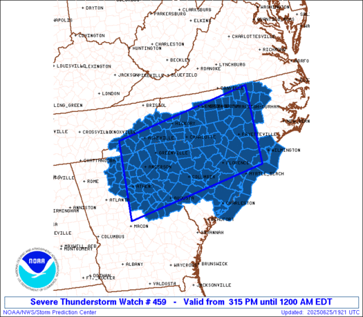
Severe Thunderstorm Watch Number 459
NWS Storm Prediction Center Norman OK
315 PM EDT Wed Jun 25 2025
The NWS Storm Prediction Center has issued a
* Severe Thunderstorm Watch for portions of
Northeast Georgia
Central and Western North Carolina
South Carolina
Coastal Waters
* Effective this Wednesday afternoon from 315 PM until Midnight
EDT.
* Primary threats include...
Scattered damaging winds likely with isolated significant gusts
to 75 mph possible
Isolated large hail events to 1.5 inches in diameter possible
SUMMARY...A very moist and unstable air mass is in place across the
watch area this afternoon. Scattered thunderstorms will develop,
tracking slowly southwestward through the evening. Damaging wind
gusts and some hail are possible in the more intense cores.
The severe thunderstorm watch area is approximately along and 90
statute miles north and south of a line from 40 miles east northeast
of Fayetteville NC to 20 miles northwest of Athens GA. For a
complete depiction of the watch see the associated watch outline
update (WOUS64 KWNS WOU9).
PRECAUTIONARY/PREPAREDNESS ACTIONS...
REMEMBER...A Severe Thunderstorm Watch means conditions are
favorable for severe thunderstorms in and close to the watch area.
Persons in these areas should be on the lookout for threatening
weather conditions and listen for later statements and possible
warnings. Severe thunderstorms can and occasionally do produce
tornadoes.
&&
AVIATION...A few severe thunderstorms with hail surface and aloft to
1.5 inches. Extreme turbulence and surface wind gusts to 65 knots. A
few cumulonimbi with maximum tops to 500. Mean storm motion vector
02025.
...Hart

   SEL9

   URGENT - IMMEDIATE BROADCAST REQUESTED
   Severe Thunderstorm Watch Number 459
   NWS Storm Prediction Center Norman OK
   315 PM EDT Wed Jun 25 2025

   The NWS Storm Prediction Center has issued a

   * Severe Thunderstorm Watch for portions of
     Northeast Georgia
     Central and Western North Carolina
     South Carolina
     Coastal Waters

   * Effective this Wednesday afternoon from 315 PM until Midnight
     EDT.

   * Primary threats include...
     Scattered damaging winds likely with isolated significant gusts
       to 75 mph possible
     Isolated large hail events to 1.5 inches in diameter possible

   SUMMARY...A very moist and unstable air mass is in place across the
   watch area this afternoon.  Scattered thunderstorms will develop,
   tracking slowly southwestward through the evening.  Damaging wind
   gusts and some hail are possible in the more intense cores.

   The severe thunderstorm watch area is approximately along and 90
   statute miles north and south of a line from 40 miles east northeast
   of Fayetteville NC to 20 miles northwest of Athens GA. For a
   complete depiction of the watch see the associated watch outline
   update (WOUS64 KWNS WOU9).

   PRECAUTIONARY/PREPAREDNESS ACTIONS...

   REMEMBER...A Severe Thunderstorm Watch means conditions are
   favorable for severe thunderstorms in and close to the watch area.
   Persons in these areas should be on the lookout for threatening
   weather conditions and listen for later statements and possible
   warnings. Severe thunderstorms can and occasionally do produce
   tornadoes.

   &&

   AVIATION...A few severe thunderstorms with hail surface and aloft to
   1.5 inches. Extreme turbulence and surface wind gusts to 65 knots. A
   few cumulonimbi with maximum tops to 500. Mean storm motion vector
   02025.

   ...Hart
 Note:
The Aviation Watch (SAW) product is an approximation to the watch area.
The actual watch is depicted by the shaded areas.
Note:
The Aviation Watch (SAW) product is an approximation to the watch area.
The actual watch is depicted by the shaded areas.
   SAW9
   WW 459 SEVERE TSTM GA NC SC CW 251915Z - 260400Z
   AXIS..90 STATUTE MILES NORTH AND SOUTH OF LINE..
   40ENE FAY/FAYETTEVILLE NC/ - 20NW AHN/ATHENS GA/
   ..AVIATION COORDS.. 80NM N/S /49SSE RDU - 36SSW ODF/
   HAIL SURFACE AND ALOFT..1.5 INCHES. WIND GUSTS..65 KNOTS.
   MAX TOPS TO 500. MEAN STORM MOTION VECTOR 02025.

   LAT...LON 33897823 32848358 35468358 36497823

   THIS IS AN APPROXIMATION TO THE WATCH AREA.  FOR A
   COMPLETE DEPICTION OF THE WATCH SEE WOUS64 KWNS
   FOR WOU9.
Watch 459 Status Report Messages:
STATUS REPORT #6 ON WW 459

VALID 260200Z - 260340Z

SEVERE WEATHER THREAT CONTINUES RIGHT OF A LINE FROM 45 ESE CHA
TO 15 NW AND TO 25 NNE OGB TO 60 ESE CHS.

..MOORE..06/26/25

ATTN...WFO...FFC...CAE...GSP...RAH...ILM...CHS...

&&

STATUS REPORT FOR WS 459

SEVERE WEATHER THREAT CONTINUES FOR THE FOLLOWING AREAS

GAC011-013-033-059-073-085-105-117-119-125-133-135-137-139-141-
147-157-163-165-181-187-189-195-211-219-221-237-245-251-257-265-
297-301-303-311-317-260340-

GA
.    GEORGIA COUNTIES INCLUDED ARE

BANKS		     BARROW		 BURKE
CLARKE		     COLUMBIA		 DAWSON
ELBERT		     FORSYTH		 FRANKLIN
GLASCOCK	     GREENE		 GWINNETT
HABERSHAM	     HALL		 HANCOCK
HART		     JACKSON		 JEFFERSON
JENKINS 	     LINCOLN		 LUMPKIN
MCDUFFIE	     MADISON		 MORGAN
OCONEE		     OGLETHORPE 	 PUTNAM
RICHMOND	     SCREVEN		 STEPHENS
TALIAFERRO	     WALTON		 WARREN
WASHINGTON	     WHITE		 WILKES
$$


SCC001-003-005-009-011-013-017-019-029-035-037-047-049-053-063-
065-075-081-260340-

SC
.    SOUTH CAROLINA COUNTIES INCLUDED ARE

ABBEVILLE	     AIKEN		 ALLENDALE
BAMBERG 	     BARNWELL		 BEAUFORT
CALHOUN 	     CHARLESTON 	 COLLETON
DORCHESTER	     EDGEFIELD		 GREENWOOD
HAMPTON 	     JASPER		 LEXINGTON
MCCORMICK	     ORANGEBURG 	 SALUDA
$$


AMZ330-350-352-260340-

CW

.    ADJACENT COASTAL WATERS INCLUDED ARE

CHARLESTON HARBOR

COASTAL WATERS FROM SOUTH SANTEE RIVER TO EDISTO BEACH SC OUT 20
NM

COASTAL WATERS FROM EDISTO BEACH SC TO SAVANNAH GA OUT 20 NM

$$
THE WATCH STATUS MESSAGE IS FOR GUIDANCE PURPOSES ONLY.  PLEASE
REFER TO WATCH COUNTY NOTIFICATION STATEMENTS FOR OFFICIAL
INFORMATION ON COUNTIES...INDEPENDENT CITIES AND MARINE ZONES
CLEARED FROM SEVERE THUNDERSTORM AND TORNADO WATCHES.
$$

STATUS REPORT #5 ON WW 459

VALID 260055Z - 260140Z

SEVERE WEATHER THREAT CONTINUES RIGHT OF A LINE FROM 50 S TYS TO
25 ENE SPA TO 40 E CLT TO 30 SSW SOP TO 40 SSW FLO TO 55 SSE CRE.

FOR ADDITIONAL INFORMATION SEE MESOSCALE DISCUSSION 1447

..MOORE..06/26/25

ATTN...WFO...FFC...CAE...GSP...RAH...ILM...CHS...

&&

STATUS REPORT FOR WS 459

SEVERE WEATHER THREAT CONTINUES FOR THE FOLLOWING AREAS

GAC011-013-033-059-073-085-105-117-119-125-133-135-137-139-141-
147-157-163-165-181-187-189-195-211-219-221-237-241-245-251-257-
265-281-291-297-301-303-311-317-260140-

GA
.    GEORGIA COUNTIES INCLUDED ARE

BANKS		     BARROW		 BURKE
CLARKE		     COLUMBIA		 DAWSON
ELBERT		     FORSYTH		 FRANKLIN
GLASCOCK	     GREENE		 GWINNETT
HABERSHAM	     HALL		 HANCOCK
HART		     JACKSON		 JEFFERSON
JENKINS 	     LINCOLN		 LUMPKIN
MCDUFFIE	     MADISON		 MORGAN
OCONEE		     OGLETHORPE 	 PUTNAM
RABUN		     RICHMOND		 SCREVEN
STEPHENS	     TALIAFERRO 	 TOWNS
UNION		     WALTON		 WARREN
WASHINGTON	     WHITE		 WILKES
$$


NCC007-179-260140-

NC
.    NORTH CAROLINA COUNTIES INCLUDED ARE

ANSON		     UNION
$$


SCC001-003-005-007-009-011-013-015-017-019-023-025-027-029-031-
035-037-039-045-047-049-053-055-057-059-061-063-065-069-071-073-
075-077-079-081-083-085-087-091-260140-

SC
.    SOUTH CAROLINA COUNTIES INCLUDED ARE

ABBEVILLE	     AIKEN		 ALLENDALE
ANDERSON	     BAMBERG		 BARNWELL
BEAUFORT	     BERKELEY		 CALHOUN
CHARLESTON	     CHESTER		 CHESTERFIELD
CLARENDON	     COLLETON		 DARLINGTON
DORCHESTER	     EDGEFIELD		 FAIRFIELD
GREENVILLE	     GREENWOOD		 HAMPTON
JASPER		     KERSHAW		 LANCASTER
LAURENS 	     LEE		 LEXINGTON
MCCORMICK	     MARLBORO		 NEWBERRY
OCONEE		     ORANGEBURG 	 PICKENS
RICHLAND	     SALUDA		 SPARTANBURG
SUMTER		     UNION		 YORK
$$


AMZ330-350-352-260140-

CW

.    ADJACENT COASTAL WATERS INCLUDED ARE

CHARLESTON HARBOR

COASTAL WATERS FROM SOUTH SANTEE RIVER TO EDISTO BEACH SC OUT 20
NM

COASTAL WATERS FROM EDISTO BEACH SC TO SAVANNAH GA OUT 20 NM

$$
THE WATCH STATUS MESSAGE IS FOR GUIDANCE PURPOSES ONLY.  PLEASE
REFER TO WATCH COUNTY NOTIFICATION STATEMENTS FOR OFFICIAL
INFORMATION ON COUNTIES...INDEPENDENT CITIES AND MARINE ZONES
CLEARED FROM SEVERE THUNDERSTORM AND TORNADO WATCHES.
$$

STATUS REPORT #4 ON WW 459

VALID 252350Z - 260040Z

SEVERE WEATHER THREAT CONTINUES RIGHT OF A LINE FROM 50 S TYS TO
25 E SPA TO 15 SSE HKY TO 10 S GSB TO 15 NNW EWN.

FOR ADDITIONAL INFORMATION SEE MESOSCALE DISCUSSION 1443

..MOORE..06/25/25

ATTN...WFO...FFC...CAE...GSP...RAH...ILM...CHS...

&&

STATUS REPORT FOR WS 459

SEVERE WEATHER THREAT CONTINUES FOR THE FOLLOWING AREAS

GAC011-013-033-059-073-085-105-117-119-125-133-135-137-139-141-
147-157-163-165-181-187-189-195-211-219-221-237-241-245-251-257-
265-281-291-297-301-303-311-317-260040-

GA
.    GEORGIA COUNTIES INCLUDED ARE

BANKS		     BARROW		 BURKE
CLARKE		     COLUMBIA		 DAWSON
ELBERT		     FORSYTH		 FRANKLIN
GLASCOCK	     GREENE		 GWINNETT
HABERSHAM	     HALL		 HANCOCK
HART		     JACKSON		 JEFFERSON
JENKINS 	     LINCOLN		 LUMPKIN
MCDUFFIE	     MADISON		 MORGAN
OCONEE		     OGLETHORPE 	 PUTNAM
RABUN		     RICHMOND		 SCREVEN
STEPHENS	     TALIAFERRO 	 TOWNS
UNION		     WALTON		 WARREN
WASHINGTON	     WHITE		 WILKES
$$


NCC007-017-019-025-047-051-071-093-109-119-123-125-129-141-153-
155-163-165-167-179-260040-

NC
.    NORTH CAROLINA COUNTIES INCLUDED ARE

ANSON		     BLADEN		 BRUNSWICK
CABARRUS	     COLUMBUS		 CUMBERLAND
GASTON		     HOKE		 LINCOLN
MECKLENBURG	     MONTGOMERY 	 MOORE
NEW HANOVER	     PENDER		 RICHMOND
ROBESON 	     SAMPSON		 SCOTLAND
STANLY		     UNION
$$


SCC001-003-005-007-009-011-013-015-017-019-023-025-027-029-031-
033-035-037-039-041-043-045-047-049-051-053-055-057-059-061-063-
065-067-069-071-073-075-077-079-081-083-085-087-089-091-
260040-

SC
.    SOUTH CAROLINA COUNTIES INCLUDED ARE

ABBEVILLE	     AIKEN		 ALLENDALE
ANDERSON	     BAMBERG		 BARNWELL
BEAUFORT	     BERKELEY		 CALHOUN
CHARLESTON	     CHESTER		 CHESTERFIELD
CLARENDON	     COLLETON		 DARLINGTON
DILLON		     DORCHESTER 	 EDGEFIELD
FAIRFIELD	     FLORENCE		 GEORGETOWN
GREENVILLE	     GREENWOOD		 HAMPTON
HORRY		     JASPER		 KERSHAW
LANCASTER	     LAURENS		 LEE
LEXINGTON	     MCCORMICK		 MARION
MARLBORO	     NEWBERRY		 OCONEE
ORANGEBURG	     PICKENS		 RICHLAND
SALUDA		     SPARTANBURG	 SUMTER
UNION		     WILLIAMSBURG	 YORK
$$


AMZ250-252-254-256-330-350-352-260040-

CW

.    ADJACENT COASTAL WATERS INCLUDED ARE

COASTAL WATERS FROM SURF CITY TO CAPE FEAR NC OUT 20 NM

COASTAL WATERS FROM CAPE FEAR NC TO LITTLE RIVER INLET SC OUT 20
NM

COASTAL WATERS FROM LITTLE RIVER INLET TO MURRELLS INLET SC OUT
20 NM

COASTAL WATERS FROM MURRELLS INLET TO SOUTH SANTEE RIVER SC OUT
20 NM

CHARLESTON HARBOR

COASTAL WATERS FROM SOUTH SANTEE RIVER TO EDISTO BEACH SC OUT 20
NM

COASTAL WATERS FROM EDISTO BEACH SC TO SAVANNAH GA OUT 20 NM

$$
THE WATCH STATUS MESSAGE IS FOR GUIDANCE PURPOSES ONLY.  PLEASE
REFER TO WATCH COUNTY NOTIFICATION STATEMENTS FOR OFFICIAL
INFORMATION ON COUNTIES...INDEPENDENT CITIES AND MARINE ZONES
CLEARED FROM SEVERE THUNDERSTORM AND TORNADO WATCHES.
$$

STATUS REPORT #3 ON WW 459

VALID 252250Z - 252340Z

SEVERE WEATHER THREAT CONTINUES RIGHT OF A LINE FROM 20 S TYS TO
20 E AVL TO 30 E HKY TO 25 NNE SOP TO 15 ESE GSB TO 30 N EWN.

FOR ADDITIONAL INFORMATION SEE MESOSCALE DISCUSSION 1443

..MOORE..06/25/25

ATTN...WFO...FFC...CAE...GSP...RAH...ILM...CHS...

&&

STATUS REPORT FOR WS 459

SEVERE WEATHER THREAT CONTINUES FOR THE FOLLOWING AREAS

GAC011-013-033-059-073-085-105-117-119-125-133-135-137-139-141-
147-157-163-181-187-189-195-211-219-221-237-241-245-257-265-281-
291-297-301-303-311-317-252340-

GA
.    GEORGIA COUNTIES INCLUDED ARE

BANKS		     BARROW		 BURKE
CLARKE		     COLUMBIA		 DAWSON
ELBERT		     FORSYTH		 FRANKLIN
GLASCOCK	     GREENE		 GWINNETT
HABERSHAM	     HALL		 HANCOCK
HART		     JACKSON		 JEFFERSON
LINCOLN 	     LUMPKIN		 MCDUFFIE
MADISON 	     MORGAN		 OCONEE
OGLETHORPE	     PUTNAM		 RABUN
RICHMOND	     STEPHENS		 TALIAFERRO
TOWNS		     UNION		 WALTON
WARREN		     WASHINGTON 	 WHITE
WILKES
$$


NCC007-017-019-025-045-047-051-071-075-085-089-093-099-105-109-
113-119-123-125-129-141-149-153-155-159-161-163-165-167-173-175-
179-252340-

NC
.    NORTH CAROLINA COUNTIES INCLUDED ARE

ANSON		     BLADEN		 BRUNSWICK
CABARRUS	     CLEVELAND		 COLUMBUS
CUMBERLAND	     GASTON		 GRAHAM
HARNETT 	     HENDERSON		 HOKE
JACKSON 	     LEE		 LINCOLN
MACON		     MECKLENBURG	 MONTGOMERY
MOORE		     NEW HANOVER	 PENDER
POLK		     RICHMOND		 ROBESON
ROWAN		     RUTHERFORD 	 SAMPSON
SCOTLAND	     STANLY		 SWAIN
TRANSYLVANIA	     UNION
$$


SCC001-003-007-009-011-015-017-019-021-023-025-027-031-033-035-
037-039-041-043-045-047-051-055-057-059-061-063-065-067-069-071-
073-075-077-079-081-083-085-087-089-091-252340-

SC
.    SOUTH CAROLINA COUNTIES INCLUDED ARE

ABBEVILLE	     AIKEN		 ANDERSON
BAMBERG 	     BARNWELL		 BERKELEY
CALHOUN 	     CHARLESTON 	 CHEROKEE
CHESTER 	     CHESTERFIELD	 CLARENDON
DARLINGTON	     DILLON		 DORCHESTER
EDGEFIELD	     FAIRFIELD		 FLORENCE
GEORGETOWN	     GREENVILLE 	 GREENWOOD
HORRY		     KERSHAW		 LANCASTER
LAURENS 	     LEE		 LEXINGTON
MCCORMICK	     MARION		 MARLBORO
NEWBERRY	     OCONEE		 ORANGEBURG
PICKENS 	     RICHLAND		 SALUDA
SPARTANBURG	     SUMTER		 UNION
WILLIAMSBURG	     YORK
$$


AMZ250-252-254-256-330-350-252340-

CW

.    ADJACENT COASTAL WATERS INCLUDED ARE

COASTAL WATERS FROM SURF CITY TO CAPE FEAR NC OUT 20 NM

COASTAL WATERS FROM CAPE FEAR NC TO LITTLE RIVER INLET SC OUT 20
NM

COASTAL WATERS FROM LITTLE RIVER INLET TO MURRELLS INLET SC OUT
20 NM

COASTAL WATERS FROM MURRELLS INLET TO SOUTH SANTEE RIVER SC OUT
20 NM

CHARLESTON HARBOR

COASTAL WATERS FROM SOUTH SANTEE RIVER TO EDISTO BEACH SC OUT 20
NM

$$
THE WATCH STATUS MESSAGE IS FOR GUIDANCE PURPOSES ONLY.  PLEASE
REFER TO WATCH COUNTY NOTIFICATION STATEMENTS FOR OFFICIAL
INFORMATION ON COUNTIES...INDEPENDENT CITIES AND MARINE ZONES
CLEARED FROM SEVERE THUNDERSTORM AND TORNADO WATCHES.
$$

STATUS REPORT #2 ON WW 459

VALID 252210Z - 252340Z

SEVERE WEATHER THREAT CONTINUES RIGHT OF A LINE FROM 25 NW HSS TO
15 NW HKY TO 10 SE GSB TO 30 N EWN.

..MOORE..06/25/25

ATTN...WFO...FFC...CAE...GSP...RAH...ILM...CHS...

&&

STATUS REPORT FOR WS 459

SEVERE WEATHER THREAT CONTINUES FOR THE FOLLOWING AREAS

GAC011-013-033-059-073-085-105-117-119-125-133-135-137-139-141-
147-157-163-181-187-189-195-211-219-221-237-241-245-257-265-281-
291-297-301-303-311-317-252340-

GA
.    GEORGIA COUNTIES INCLUDED ARE

BANKS		     BARROW		 BURKE
CLARKE		     COLUMBIA		 DAWSON
ELBERT		     FORSYTH		 FRANKLIN
GLASCOCK	     GREENE		 GWINNETT
HABERSHAM	     HALL		 HANCOCK
HART		     JACKSON		 JEFFERSON
LINCOLN 	     LUMPKIN		 MCDUFFIE
MADISON 	     MORGAN		 OCONEE
OGLETHORPE	     PUTNAM		 RABUN
RICHMOND	     STEPHENS		 TALIAFERRO
TOWNS		     UNION		 WALTON
WARREN		     WASHINGTON 	 WHITE
WILKES
$$


NCC007-017-019-021-023-025-035-045-047-051-071-075-085-087-089-
093-099-105-109-111-113-115-119-123-125-129-141-149-153-155-159-
161-163-165-167-173-175-179-199-252340-

NC
.    NORTH CAROLINA COUNTIES INCLUDED ARE

ANSON		     BLADEN		 BRUNSWICK
BUNCOMBE	     BURKE		 CABARRUS
CATAWBA 	     CLEVELAND		 COLUMBUS
CUMBERLAND	     GASTON		 GRAHAM
HARNETT 	     HAYWOOD		 HENDERSON
HOKE		     JACKSON		 LEE
LINCOLN 	     MCDOWELL		 MACON
MADISON 	     MECKLENBURG	 MONTGOMERY
MOORE		     NEW HANOVER	 PENDER
POLK		     RICHMOND		 ROBESON
ROWAN		     RUTHERFORD 	 SAMPSON
SCOTLAND	     STANLY		 SWAIN
TRANSYLVANIA	     UNION		 YANCEY
$$


SCC001-003-007-009-011-015-017-019-021-023-025-027-031-033-035-
037-039-041-043-045-047-051-055-057-059-061-063-065-067-069-071-
073-075-077-079-081-083-085-087-089-091-252340-

SC
.    SOUTH CAROLINA COUNTIES INCLUDED ARE

ABBEVILLE	     AIKEN		 ANDERSON
BAMBERG 	     BARNWELL		 BERKELEY
CALHOUN 	     CHARLESTON 	 CHEROKEE
CHESTER 	     CHESTERFIELD	 CLARENDON
DARLINGTON	     DILLON		 DORCHESTER
EDGEFIELD	     FAIRFIELD		 FLORENCE
GEORGETOWN	     GREENVILLE 	 GREENWOOD
HORRY		     KERSHAW		 LANCASTER
LAURENS 	     LEE		 LEXINGTON
MCCORMICK	     MARION		 MARLBORO
NEWBERRY	     OCONEE		 ORANGEBURG
PICKENS 	     RICHLAND		 SALUDA
SPARTANBURG	     SUMTER		 UNION
WILLIAMSBURG	     YORK
$$


AMZ250-252-254-256-330-350-252340-

CW

.    ADJACENT COASTAL WATERS INCLUDED ARE

COASTAL WATERS FROM SURF CITY TO CAPE FEAR NC OUT 20 NM

COASTAL WATERS FROM CAPE FEAR NC TO LITTLE RIVER INLET SC OUT 20
NM

COASTAL WATERS FROM LITTLE RIVER INLET TO MURRELLS INLET SC OUT
20 NM

COASTAL WATERS FROM MURRELLS INLET TO SOUTH SANTEE RIVER SC OUT
20 NM

CHARLESTON HARBOR

COASTAL WATERS FROM SOUTH SANTEE RIVER TO EDISTO BEACH SC OUT 20
NM

$$
THE WATCH STATUS MESSAGE IS FOR GUIDANCE PURPOSES ONLY.  PLEASE
REFER TO WATCH COUNTY NOTIFICATION STATEMENTS FOR OFFICIAL
INFORMATION ON COUNTIES...INDEPENDENT CITIES AND MARINE ZONES
CLEARED FROM SEVERE THUNDERSTORM AND TORNADO WATCHES.
$$

STATUS REPORT #1 ON WW 459

VALID 252005Z - 252140Z

THE SEVERE WEATHER THREAT CONTINUES ACROSS THE ENTIRE WATCH AREA.

..DEAN..06/25/25

ATTN...WFO...FFC...CAE...GSP...RAH...ILM...CHS...

&&

STATUS REPORT FOR WS 459

SEVERE WEATHER THREAT CONTINUES FOR THE FOLLOWING AREAS

GAC011-013-033-059-073-085-105-117-119-125-133-135-137-139-141-
147-157-163-181-187-189-195-211-219-221-237-241-245-257-265-281-
291-297-301-303-311-317-252140-

GA
.    GEORGIA COUNTIES INCLUDED ARE

BANKS		     BARROW		 BURKE
CLARKE		     COLUMBIA		 DAWSON
ELBERT		     FORSYTH		 FRANKLIN
GLASCOCK	     GREENE		 GWINNETT
HABERSHAM	     HALL		 HANCOCK
HART		     JACKSON		 JEFFERSON
LINCOLN 	     LUMPKIN		 MCDUFFIE
MADISON 	     MORGAN		 OCONEE
OGLETHORPE	     PUTNAM		 RABUN
RICHMOND	     STEPHENS		 TALIAFERRO
TOWNS		     UNION		 WALTON
WARREN		     WASHINGTON 	 WHITE
WILKES
$$


NCC001-003-007-011-017-019-021-023-025-027-035-037-045-047-051-
057-059-063-065-067-069-071-075-077-081-083-085-087-089-093-097-
099-101-105-109-111-113-115-119-121-123-125-127-129-135-141-145-
149-151-153-155-159-161-163-165-167-173-175-179-181-183-185-191-
195-199-252140-

NC
.    NORTH CAROLINA COUNTIES INCLUDED ARE

ALAMANCE	     ALEXANDER		 ANSON
AVERY		     BLADEN		 BRUNSWICK
BUNCOMBE	     BURKE		 CABARRUS
CALDWELL	     CATAWBA		 CHATHAM
CLEVELAND	     COLUMBUS		 CUMBERLAND
DAVIDSON	     DAVIE		 DURHAM
EDGECOMBE	     FORSYTH		 FRANKLIN
GASTON		     GRAHAM		 GRANVILLE
GUILFORD	     HALIFAX		 HARNETT
HAYWOOD 	     HENDERSON		 HOKE
IREDELL 	     JACKSON		 JOHNSTON
LEE		     LINCOLN		 MCDOWELL
MACON		     MADISON		 MECKLENBURG
MITCHELL	     MONTGOMERY 	 MOORE
NASH		     NEW HANOVER	 ORANGE
PENDER		     PERSON		 POLK
RANDOLPH	     RICHMOND		 ROBESON
ROWAN		     RUTHERFORD 	 SAMPSON
SCOTLAND	     STANLY		 SWAIN
TRANSYLVANIA	     UNION		 VANCE
WAKE		     WARREN		 WAYNE
WILSON		     YANCEY
$$


SCC001-003-007-009-011-015-017-019-021-023-025-027-031-033-035-
037-039-041-043-045-047-051-055-057-059-061-063-065-067-069-071-
073-075-077-079-081-083-085-087-089-091-252140-

SC
.    SOUTH CAROLINA COUNTIES INCLUDED ARE

ABBEVILLE	     AIKEN		 ANDERSON
BAMBERG 	     BARNWELL		 BERKELEY
CALHOUN 	     CHARLESTON 	 CHEROKEE
CHESTER 	     CHESTERFIELD	 CLARENDON
DARLINGTON	     DILLON		 DORCHESTER
EDGEFIELD	     FAIRFIELD		 FLORENCE
GEORGETOWN	     GREENVILLE 	 GREENWOOD
HORRY		     KERSHAW		 LANCASTER
LAURENS 	     LEE		 LEXINGTON
MCCORMICK	     MARION		 MARLBORO
NEWBERRY	     OCONEE		 ORANGEBURG
PICKENS 	     RICHLAND		 SALUDA
SPARTANBURG	     SUMTER		 UNION
WILLIAMSBURG	     YORK
$$


AMZ250-252-254-256-330-350-252140-

CW

.    ADJACENT COASTAL WATERS INCLUDED ARE

COASTAL WATERS FROM SURF CITY TO CAPE FEAR NC OUT 20 NM

COASTAL WATERS FROM CAPE FEAR NC TO LITTLE RIVER INLET SC OUT 20
NM

COASTAL WATERS FROM LITTLE RIVER INLET TO MURRELLS INLET SC OUT
20 NM

COASTAL WATERS FROM MURRELLS INLET TO SOUTH SANTEE RIVER SC OUT
20 NM

CHARLESTON HARBOR

COASTAL WATERS FROM SOUTH SANTEE RIVER TO EDISTO BEACH SC OUT 20
NM

$$
THE WATCH STATUS MESSAGE IS FOR GUIDANCE PURPOSES ONLY.  PLEASE
REFER TO WATCH COUNTY NOTIFICATION STATEMENTS FOR OFFICIAL
INFORMATION ON COUNTIES...INDEPENDENT CITIES AND MARINE ZONES
CLEARED FROM SEVERE THUNDERSTORM AND TORNADO WATCHES.
$$
Note:
Click for Complete Product Text.
Tornadoes
Probability of 2 or more tornadoes
|
Low (<5%)
|
Probability of 1 or more strong (EF2-EF5) tornadoes
|
Low (<2%)
|
Wind
Probability of 10 or more severe wind events
|
High (70%)
|
Probability of 1 or more wind events > 65 knots
|
Mod (30%)
|
Hail
Probability of 10 or more severe hail events
|
Mod (30%)
|
Probability of 1 or more hailstones > 2 inches
|
Low (10%)
|
Combined Severe Hail/Wind
Probability of 6 or more combined severe hail/wind events
|
High (90%)
|
For each watch, probabilities for particular events inside the watch
(listed above in each table) are determined by the issuing forecaster.
The "Low" category contains probability values ranging from less than 2%
to 20% (EF2-EF5 tornadoes), less than 5% to 20% (all other probabilities),
"Moderate" from 30% to 60%, and "High" from 70% to greater than 95%.
High values are bolded and lighter in color to provide awareness of
an increased threat for a particular event.


 @NWSSPC


