Note:
The expiration time in the watch graphic is amended if the watch is
replaced, cancelled or extended.
Note:
Note:
The expiration time in the watch graphic is amended if the watch is
replaced, cancelled or extended.
Note: Click for
Watch Status Reports.
SEL1
URGENT - IMMEDIATE BROADCAST REQUESTED
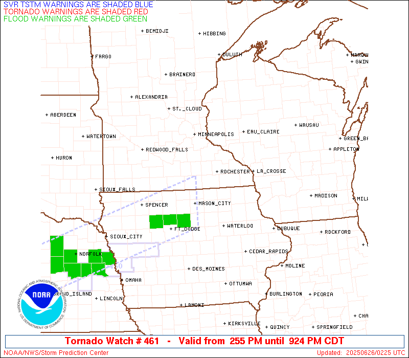
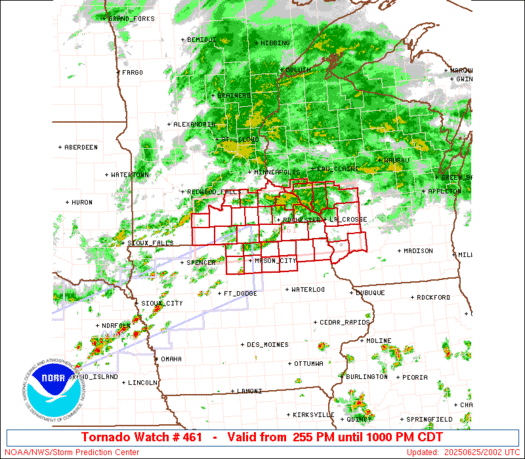
Tornado Watch Number 461
NWS Storm Prediction Center Norman OK
255 PM CDT Wed Jun 25 2025
The NWS Storm Prediction Center has issued a
* Tornado Watch for portions of
Northeast Iowa
Southeast Minnesota
Southwest Wisconsin
* Effective this Wednesday afternoon and evening from 255 PM
until 1000 PM CDT.
* Primary threats include...
A couple tornadoes possible
Scattered damaging wind gusts to 70 mph possible
SUMMARY...Isolated supercell thunderstorms are likely to intensify
in the next few hours across southern Minnesota, in a moist and
moderately sheared environment. These storms will track eastward
across the watch area, posing a risk of a few tornadoes and damaging
wind gusts.
The tornado watch area is approximately along and 45 statute miles
north and south of a line from 20 miles west northwest of Fairmont
MN to 45 miles east of La Crosse WI. For a complete depiction of the
watch see the associated watch outline update (WOUS64 KWNS WOU1).
PRECAUTIONARY/PREPAREDNESS ACTIONS...
REMEMBER...A Tornado Watch means conditions are favorable for
tornadoes and severe thunderstorms in and close to the watch
area. Persons in these areas should be on the lookout for
threatening weather conditions and listen for later statements
and possible warnings.
&&
OTHER WATCH INFORMATION...CONTINUE...WW 459...WW 460...
AVIATION...Tornadoes and a few severe thunderstorms with hail
surface and aloft to 1.5 inches. Extreme turbulence and surface wind
gusts to 60 knots. A few cumulonimbi with maximum tops to 500. Mean
storm motion vector 27030.
...Hart
   SEL1

   URGENT - IMMEDIATE BROADCAST REQUESTED
   Tornado Watch Number 461
   NWS Storm Prediction Center Norman OK
   255 PM CDT Wed Jun 25 2025

   The NWS Storm Prediction Center has issued a

   * Tornado Watch for portions of
     Northeast Iowa
     Southeast Minnesota
     Southwest Wisconsin

   * Effective this Wednesday afternoon and evening from 255 PM
     until 1000 PM CDT.

   * Primary threats include...
     A couple tornadoes possible
     Scattered damaging wind gusts to 70 mph possible

   SUMMARY...Isolated supercell thunderstorms are likely to intensify
   in the next few hours across southern Minnesota, in a moist and
   moderately sheared environment.  These storms will track eastward
   across the watch area, posing a risk of a few tornadoes and damaging
   wind gusts.

   The tornado watch area is approximately along and 45 statute miles
   north and south of a line from 20 miles west northwest of Fairmont
   MN to 45 miles east of La Crosse WI. For a complete depiction of the
   watch see the associated watch outline update (WOUS64 KWNS WOU1).

   PRECAUTIONARY/PREPAREDNESS ACTIONS...

   REMEMBER...A Tornado Watch means conditions are favorable for
   tornadoes and severe thunderstorms in and close to the watch
   area. Persons in these areas should be on the lookout for
   threatening weather conditions and listen for later statements
   and possible warnings.

   &&

   OTHER WATCH INFORMATION...CONTINUE...WW 459...WW 460...

   AVIATION...Tornadoes and a few severe thunderstorms with hail
   surface and aloft to 1.5 inches. Extreme turbulence and surface wind
   gusts to 60 knots. A few cumulonimbi with maximum tops to 500. Mean
   storm motion vector 27030.

   ...Hart
 Note:
The Aviation Watch (SAW) product is an approximation to the watch area.
The actual watch is depicted by the shaded areas.
Note:
The Aviation Watch (SAW) product is an approximation to the watch area.
The actual watch is depicted by the shaded areas.
   SAW1
   WW 461 TORNADO IA MN WI 251955Z - 260300Z
   AXIS..45 STATUTE MILES NORTH AND SOUTH OF LINE..
   20WNW FRM/FAIRMONT MN/ - 45E LSE/LA CROSSE WI/
   ..AVIATION COORDS.. 40NM N/S /45SSE RWF - 32NW DLL/
   HAIL SURFACE AND ALOFT..1.5 INCHES. WIND GUSTS..60 KNOTS.
   MAX TOPS TO 500. MEAN STORM MOTION VECTOR 27030.

   LAT...LON 44419479 44539035 43239035 43119479

   THIS IS AN APPROXIMATION TO THE WATCH AREA.  FOR A
   COMPLETE DEPICTION OF THE WATCH SEE WOUS64 KWNS
   FOR WOU1.
Watch 461 Status Report Messages:
STATUS REPORT #3 ON WW 461

VALID 260130Z - 260300Z

SEVERE WEATHER THREAT CONTINUES RIGHT OF A LINE FROM 50 W LNR TO
20 SW VOK TO 10 NNE VOK.

WW 461 WILL BE ALLOWED TO EXPIRE AT 260300Z.

..SQUITIERI..06/26/25

ATTN...WFO...ARX...DMX...MPX...

&&

STATUS REPORT FOR WT 461

SEVERE WEATHER THREAT CONTINUES FOR THE FOLLOWING AREAS

WIC023-103-260300-

WI
.    WISCONSIN COUNTIES INCLUDED ARE

CRAWFORD	     RICHLAND
$$


THE WATCH STATUS MESSAGE IS FOR GUIDANCE PURPOSES ONLY.  PLEASE
REFER TO WATCH COUNTY NOTIFICATION STATEMENTS FOR OFFICIAL
INFORMATION ON COUNTIES...INDEPENDENT CITIES AND MARINE ZONES
CLEARED FROM SEVERE THUNDERSTORM AND TORNADO WATCHES.
$$

STATUS REPORT #2 ON WW 461

VALID 260005Z - 260140Z

SEVERE WEATHER THREAT CONTINUES RIGHT OF A LINE FROM 45 NNE ALO
TO 30 ESE RST TO 25 N VOK.

..SQUITIERI..06/26/25

ATTN...WFO...ARX...DMX...MPX...

&&

STATUS REPORT FOR WT 461

SEVERE WEATHER THREAT CONTINUES FOR THE FOLLOWING AREAS

IAC005-191-260140-

IA
.    IOWA COUNTIES INCLUDED ARE

ALLAMAKEE	     WINNESHIEK
$$


MNC045-055-260140-

MN
.    MINNESOTA COUNTIES INCLUDED ARE

FILLMORE	     HOUSTON
$$


WIC023-063-081-103-123-260140-

WI
.    WISCONSIN COUNTIES INCLUDED ARE

CRAWFORD	     LA CROSSE		 MONROE
RICHLAND	     VERNON
$$


THE WATCH STATUS MESSAGE IS FOR GUIDANCE PURPOSES ONLY.  PLEASE
REFER TO WATCH COUNTY NOTIFICATION STATEMENTS FOR OFFICIAL
INFORMATION ON COUNTIES...INDEPENDENT CITIES AND MARINE ZONES
CLEARED FROM SEVERE THUNDERSTORM AND TORNADO WATCHES.
$$

STATUS REPORT #1 ON WW 461

VALID 252205Z - 252340Z

SEVERE WEATHER THREAT CONTINUES RIGHT OF A LINE FROM 35 N FOD TO
15 NE FRM TO 30 SE MSP.

FOR ADDITIONAL INFORMATION SEE MESOSCALE DISCUSSION 1442

..SQUITIERI..06/25/25

ATTN...WFO...ARX...DMX...MPX...

&&

STATUS REPORT FOR WT 461

SEVERE WEATHER THREAT CONTINUES FOR THE FOLLOWING AREAS

IAC005-033-037-067-081-089-131-189-191-195-252340-

IA
.    IOWA COUNTIES INCLUDED ARE

ALLAMAKEE	     CERRO GORDO	 CHICKASAW
FLOYD		     HANCOCK		 HOWARD
MITCHELL	     WINNEBAGO		 WINNESHIEK
WORTH
$$


MNC039-043-045-047-049-055-099-109-131-147-157-161-169-252340-

MN
.    MINNESOTA COUNTIES INCLUDED ARE

DODGE		     FARIBAULT		 FILLMORE
FREEBORN	     GOODHUE		 HOUSTON
MOWER		     OLMSTED		 RICE
STEELE		     WABASHA		 WASECA
WINONA
$$


WIC011-023-053-063-081-091-103-121-123-252340-

WI
.    WISCONSIN COUNTIES INCLUDED ARE

BUFFALO 	     CRAWFORD		 JACKSON
LA CROSSE	     MONROE		 PEPIN
RICHLAND	     TREMPEALEAU	 VERNON
$$


THE WATCH STATUS MESSAGE IS FOR GUIDANCE PURPOSES ONLY.  PLEASE
REFER TO WATCH COUNTY NOTIFICATION STATEMENTS FOR OFFICIAL
INFORMATION ON COUNTIES...INDEPENDENT CITIES AND MARINE ZONES
CLEARED FROM SEVERE THUNDERSTORM AND TORNADO WATCHES.
$$


 @NWSSPC