Note:
The expiration time in the watch graphic is amended if the watch is
replaced, cancelled or extended.
Note:
Note:
The expiration time in the watch graphic is amended if the watch is
replaced, cancelled or extended.
Note: Click for
Watch Status Reports.
SEL2
URGENT - IMMEDIATE BROADCAST REQUESTED
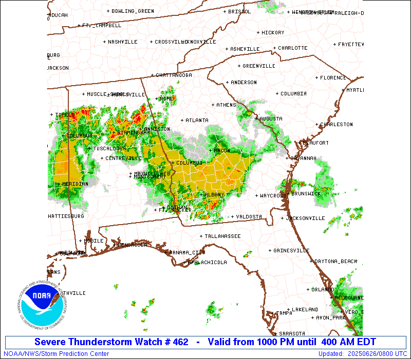
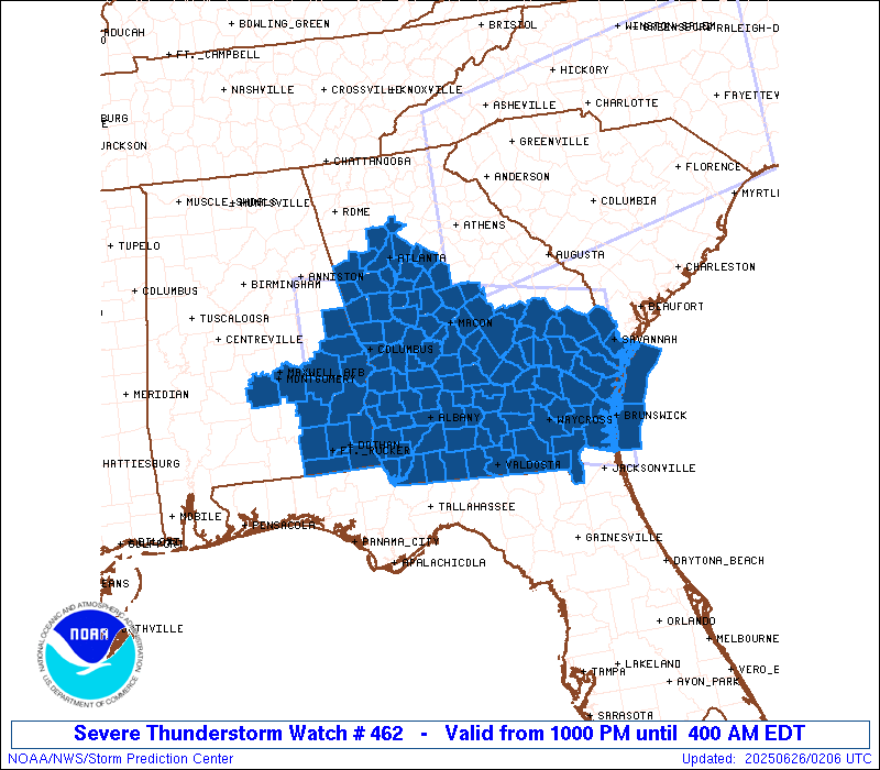
Severe Thunderstorm Watch Number 462
NWS Storm Prediction Center Norman OK
1000 PM EDT Wed Jun 25 2025
The NWS Storm Prediction Center has issued a
* Severe Thunderstorm Watch for portions of
Southeast Alabama
Georgia
Coastal Waters
* Effective this Wednesday night and Thursday morning from 1000
PM until 400 AM EDT.
* Primary threats include...
Scattered damaging wind gusts to 70 mph likely
SUMMARY...The environment will support a relatively long-duration
potential of severe storms into the overnight, with a loosely
organized complex of storms moving generally south-southwestward
tonight out of South Carolina into Georgia, while additional storms
continue across southwest Georgia and southeast Alabama. Wind damage
is the primary hazard.
The severe thunderstorm watch area is approximately along and 80
statute miles north and south of a line from 35 miles west southwest
of Auburn AL to 35 miles north northeast of Brunswick GA. For a
complete depiction of the watch see the associated watch outline
update (WOUS64 KWNS WOU2).
PRECAUTIONARY/PREPAREDNESS ACTIONS...
REMEMBER...A Severe Thunderstorm Watch means conditions are
favorable for severe thunderstorms in and close to the watch area.
Persons in these areas should be on the lookout for threatening
weather conditions and listen for later statements and possible
warnings. Severe thunderstorms can and occasionally do produce
tornadoes.
&&
OTHER WATCH INFORMATION...CONTINUE...WW 459...WW 460...WW 461...
AVIATION...A few severe thunderstorms with hail surface and aloft to
1 inch. Extreme turbulence and surface wind gusts to 60 knots. A few
cumulonimbi with maximum tops to 550. Mean storm motion vector
07020.
...Guyer
   SEL2

   URGENT - IMMEDIATE BROADCAST REQUESTED
   Severe Thunderstorm Watch Number 462
   NWS Storm Prediction Center Norman OK
   1000 PM EDT Wed Jun 25 2025

   The NWS Storm Prediction Center has issued a

   * Severe Thunderstorm Watch for portions of
     Southeast Alabama
     Georgia
     Coastal Waters

   * Effective this Wednesday night and Thursday morning from 1000
     PM until 400 AM EDT.

   * Primary threats include...
     Scattered damaging wind gusts to 70 mph likely

   SUMMARY...The environment will support a relatively long-duration
   potential of severe storms into the overnight, with a loosely
   organized complex of storms moving generally south-southwestward
   tonight out of South Carolina into Georgia, while additional storms
   continue across southwest Georgia and southeast Alabama. Wind damage
   is the primary hazard.

   The severe thunderstorm watch area is approximately along and 80
   statute miles north and south of a line from 35 miles west southwest
   of Auburn AL to 35 miles north northeast of Brunswick GA. For a
   complete depiction of the watch see the associated watch outline
   update (WOUS64 KWNS WOU2).

   PRECAUTIONARY/PREPAREDNESS ACTIONS...

   REMEMBER...A Severe Thunderstorm Watch means conditions are
   favorable for severe thunderstorms in and close to the watch area.
   Persons in these areas should be on the lookout for threatening
   weather conditions and listen for later statements and possible
   warnings. Severe thunderstorms can and occasionally do produce
   tornadoes.

   &&

   OTHER WATCH INFORMATION...CONTINUE...WW 459...WW 460...WW 461...

   AVIATION...A few severe thunderstorms with hail surface and aloft to
   1 inch. Extreme turbulence and surface wind gusts to 60 knots. A few
   cumulonimbi with maximum tops to 550. Mean storm motion vector
   07020.

   ...Guyer
 Note:
The Aviation Watch (SAW) product is an approximation to the watch area.
The actual watch is depicted by the shaded areas.
Note:
The Aviation Watch (SAW) product is an approximation to the watch area.
The actual watch is depicted by the shaded areas.
   SAW2
   WW 462 SEVERE TSTM AL GA CW 260200Z - 260800Z
   AXIS..80 STATUTE MILES NORTH AND SOUTH OF LINE..
   35WSW AUO/AUBURN AL/ - 35NNE SSI/BRUNSWICK GA/
   ..AVIATION COORDS.. 70NM N/S /21NE MGM - 33S SAV/
   HAIL SURFACE AND ALOFT..1 INCH. WIND GUSTS..60 KNOTS.
   MAX TOPS TO 550. MEAN STORM MOTION VECTOR 07020.

   LAT...LON 33578598 32788122 30468122 31268598

   THIS IS AN APPROXIMATION TO THE WATCH AREA.  FOR A
   COMPLETE DEPICTION OF THE WATCH SEE WOUS64 KWNS
   FOR WOU2.
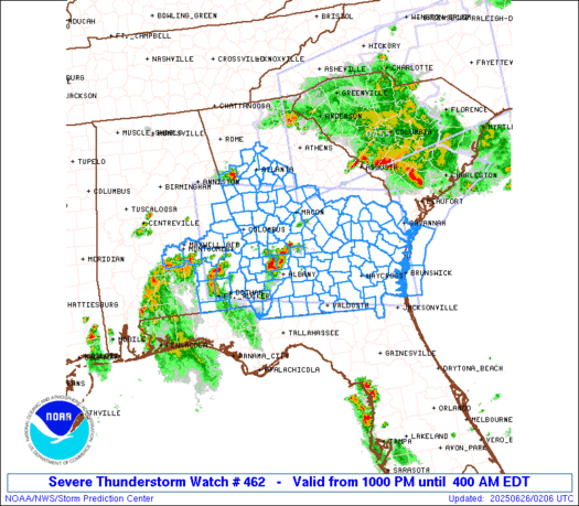
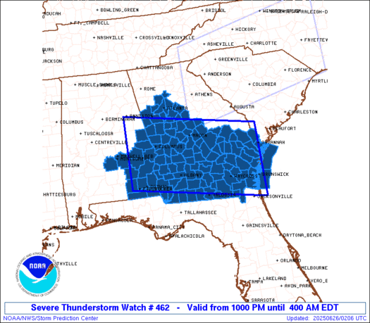
Watch 462 Status Report Messages:
STATUS REPORT #2 ON WW 462

VALID 260635Z - 260740Z

SEVERE WEATHER THREAT CONTINUES RIGHT OF A LINE FROM 30 WSW ATL
TO 20 ESE LGC TO 40 ESE CSG TO 35 SSW MCN TO 50 NE ABY TO 50 WSW
VDI TO 35 SSW VDI TO 25 SSE AYS TO 40 WSW JAX.

FOR ADDITIONAL INFORMATION SEE MESOSCALE DISCUSSION 1451

..WENDT..06/26/25

ATTN...WFO...BMX...TAE...JAX...FFC...CHS...

&&

STATUS REPORT FOR WS 462

SEVERE WEATHER THREAT CONTINUES FOR THE FOLLOWING AREAS

ALC005-011-017-031-037-045-051-061-067-069-081-087-101-109-113-
123-260740-

AL
.    ALABAMA COUNTIES INCLUDED ARE

BARBOUR 	     BULLOCK		 CHAMBERS
COFFEE		     COOSA		 DALE
ELMORE		     GENEVA		 HENRY
HOUSTON 	     LEE		 MACON
MONTGOMERY	     PIKE		 RUSSELL
TALLAPOOSA
$$


GAC003-007-017-019-027-037-053-061-065-069-071-075-081-087-093-
095-099-101-131-145-149-155-173-177-185-197-201-205-215-239-243-
249-253-259-261-273-275-277-285-287-299-307-315-321-260740-

GA
.    GEORGIA COUNTIES INCLUDED ARE

ATKINSON	     BAKER		 BEN HILL
BERRIEN 	     BROOKS		 CALHOUN
CHATTAHOOCHEE	     CLAY		 CLINCH
COFFEE		     COLQUITT		 COOK
CRISP		     DECATUR		 DOOLY
DOUGHERTY	     EARLY		 ECHOLS
GRADY		     HARRIS		 HEARD
IRWIN		     LANIER		 LEE
LOWNDES 	     MARION		 MILLER
MITCHELL	     MUSCOGEE		 QUITMAN
RANDOLPH	     SCHLEY		 SEMINOLE
STEWART 	     SUMTER		 TERRELL
THOMAS		     TIFT		 TROUP
TURNER		     WARE		 WEBSTER
WILCOX		     WORTH
$$


THE WATCH STATUS MESSAGE IS FOR GUIDANCE PURPOSES ONLY.  PLEASE
REFER TO WATCH COUNTY NOTIFICATION STATEMENTS FOR OFFICIAL
INFORMATION ON COUNTIES...INDEPENDENT CITIES AND MARINE ZONES
CLEARED FROM SEVERE THUNDERSTORM AND TORNADO WATCHES.
$$

STATUS REPORT #1 ON WW 462

VALID 260530Z - 260640Z

SEVERE WEATHER THREAT CONTINUES RIGHT OF A LINE FROM 15 NE ANB TO
25 SW ATL TO 35 NNW MCN TO 30 ENE MCN TO 25 NW VDI TO 25 SE VDI
TO 25 E SSI.

..WENDT..06/26/25

ATTN...WFO...BMX...TAE...JAX...FFC...CHS...

&&

STATUS REPORT FOR WS 462

SEVERE WEATHER THREAT CONTINUES FOR THE FOLLOWING AREAS

ALC001-005-011-017-021-031-037-045-047-051-061-067-069-081-085-
087-091-101-105-109-113-123-260640-

AL
.    ALABAMA COUNTIES INCLUDED ARE

AUTAUGA 	     BARBOUR		 BULLOCK
CHAMBERS	     CHILTON		 COFFEE
COOSA		     DALE		 DALLAS
ELMORE		     GENEVA		 HENRY
HOUSTON 	     LEE		 LOWNDES
MACON		     MARENGO		 MONTGOMERY
PERRY		     PIKE		 RUSSELL
TALLAPOOSA
$$


GAC001-003-005-007-017-019-021-023-025-027-037-039-049-053-061-
065-069-071-075-077-079-081-087-091-093-095-099-101-127-131-145-
149-153-155-161-171-173-175-177-185-193-197-199-201-205-207-209-
215-225-229-231-235-239-243-249-253-259-261-263-269-271-273-275-
277-285-287-289-293-299-305-307-309-315-321-260640-

GA
.    GEORGIA COUNTIES INCLUDED ARE

APPLING 	     ATKINSON		 BACON
BAKER		     BEN HILL		 BERRIEN
BIBB		     BLECKLEY		 BRANTLEY
BROOKS		     CALHOUN		 CAMDEN
CHARLTON	     CHATTAHOOCHEE	 CLAY
CLINCH		     COFFEE		 COLQUITT
COOK		     COWETA		 CRAWFORD
CRISP		     DECATUR		 DODGE
DOOLY		     DOUGHERTY		 EARLY
ECHOLS		     GLYNN		 GRADY
HARRIS		     HEARD		 HOUSTON
IRWIN		     JEFF DAVIS 	 LAMAR
LANIER		     LAURENS		 LEE
LOWNDES 	     MACON		 MARION
MERIWETHER	     MILLER		 MITCHELL
MONROE		     MONTGOMERY 	 MUSCOGEE
PEACH		     PIERCE		 PIKE
PULASKI 	     QUITMAN		 RANDOLPH
SCHLEY		     SEMINOLE		 STEWART
SUMTER		     TALBOT		 TAYLOR
TELFAIR 	     TERRELL		 THOMAS
TIFT		     TROUP		 TURNER
TWIGGS		     UPSON		 WARE
WAYNE		     WEBSTER		 WHEELER
WILCOX		     WORTH
$$


AMZ450-260640-

CW

.    ADJACENT COASTAL WATERS INCLUDED ARE

COASTAL WATERS FROM ALTAMAHA SOUND TO FERNANDINA BEACH FL OUT 20
NM

$$
THE WATCH STATUS MESSAGE IS FOR GUIDANCE PURPOSES ONLY.  PLEASE
REFER TO WATCH COUNTY NOTIFICATION STATEMENTS FOR OFFICIAL
INFORMATION ON COUNTIES...INDEPENDENT CITIES AND MARINE ZONES
CLEARED FROM SEVERE THUNDERSTORM AND TORNADO WATCHES.
$$
Note:
Click for Complete Product Text.
Tornadoes
Probability of 2 or more tornadoes
|
Low (<5%)
|
Probability of 1 or more strong (EF2-EF5) tornadoes
|
Low (<2%)
|
Wind
Probability of 10 or more severe wind events
|
Mod (60%)
|
Probability of 1 or more wind events > 65 knots
|
Low (10%)
|
Hail
Probability of 10 or more severe hail events
|
Low (10%)
|
Probability of 1 or more hailstones > 2 inches
|
Low (10%)
|
Combined Severe Hail/Wind
Probability of 6 or more combined severe hail/wind events
|
High (80%)
|
For each watch, probabilities for particular events inside the watch
(listed above in each table) are determined by the issuing forecaster.
The "Low" category contains probability values ranging from less than 2%
to 20% (EF2-EF5 tornadoes), less than 5% to 20% (all other probabilities),
"Moderate" from 30% to 60%, and "High" from 70% to greater than 95%.
High values are bolded and lighter in color to provide awareness of
an increased threat for a particular event.


 @NWSSPC